

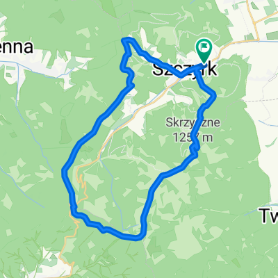
Szczyrk - Skrzyczne - Malinowska Skała - Jaskinia Malinowska - Przełęcz Salmopolska
A cycling route starting in Szczyrk, Silesian Voivodeship, Poland.
Overview
About this route
- -:--
- Duration
- 23.4 km
- Distance
- 856 m
- Ascent
- 863 m
- Descent
- ---
- Avg. speed
- ---
- Avg. speed

Continue with Bikemap
Use, edit, or download this cycling route
You would like to ride Szczyrk - Skrzyczne - Malinowska Skała - Jaskinia Malinowska - Przełęcz Salmopolska or customize it for your own trip? Here is what you can do with this Bikemap route:
Free features
- Save this route as favorite or in collections
- Copy & plan your own version of this route
- Sync your route with Garmin or Wahoo
Premium features
Free trial for 3 days, or one-time payment. More about Bikemap Premium.
- Navigate this route on iOS & Android
- Export a GPX / KML file of this route
- Create your custom printout (try it for free)
- Download this route for offline navigation
Discover more Premium features.
Get Bikemap PremiumFrom our community
Other popular routes starting in Szczyrk
 2013-05-31 Szczyrk #4
- Distance
- 52 km
- Ascent
- 1,977 m
- Descent
- 1,971 m
- Location
- Szczyrk, Silesian Voivodeship, Poland
 Skrzyczne Lipowa Buczkowice Szczyrk
- Distance
- 30.1 km
- Ascent
- 302 m
- Descent
- 1,023 m
- Location
- Szczyrk, Silesian Voivodeship, Poland
 dookoła skrzycznego
- Distance
- 71.8 km
- Ascent
- 995 m
- Descent
- 987 m
- Location
- Szczyrk, Silesian Voivodeship, Poland
 Snail-like route in Szczyrk
- Distance
- 20.1 km
- Ascent
- 778 m
- Descent
- 789 m
- Location
- Szczyrk, Silesian Voivodeship, Poland
 2018 Żywiec dzień 2
- Distance
- 84.5 km
- Ascent
- 1,242 m
- Descent
- 1,243 m
- Location
- Szczyrk, Silesian Voivodeship, Poland
 Szczyrk Klimczok Wisła Brenna
- Distance
- 53.3 km
- Ascent
- 1,629 m
- Descent
- 1,627 m
- Location
- Szczyrk, Silesian Voivodeship, Poland
 Kotarz,Salmopol, Skrzyczne
- Distance
- 26.2 km
- Ascent
- 983 m
- Descent
- 983 m
- Location
- Szczyrk, Silesian Voivodeship, Poland
 Skrzyczne-Barania Góra
- Distance
- 44.5 km
- Ascent
- 1,005 m
- Descent
- 1,467 m
- Location
- Szczyrk, Silesian Voivodeship, Poland
Open it in the app