

Rzeszów - Turza - Widełka - Budy Gł.
A cycling route starting in Rzeszów, Subcarpathian Voivodeship, Poland.
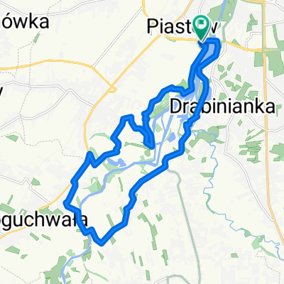
Overview
About this route
Spokojna traska. Dużo lasów i piękna przyrody. Polecam raczej NIE po opadach deszczu chyba, żektoś lubi trochu błotka na swoim rumaku.
- -:--
- Duration
- 85.4 km
- Distance
- 237 m
- Ascent
- 213 m
- Descent
- ---
- Avg. speed
- ---
- Avg. speed
Route highlights
Points of interest along the route
Point of interest after 9.3 km
Bardzo dobry punkt widokowy na startujące i lądujące samoloty.
Point of interest after 20.4 km
Miejsce do wypoczynku z grzybkami (przed deszczem). Proszę po sobie zostawić porządek. Teren jest prywatny.
Point of interest after 25.5 km
Ładne nieduże jeziorko w lesie.
Point of interest after 28 km
Leśniczówka Hucisko. Można z drogi zobaczyć prawdziwe dziki.
Point of interest after 33.9 km
Mogiły ofiar pomordowanych przez Sowietów w Turzy
Point of interest after 49.8 km
Nieduży zalew nad Zyzogą
Point of interest after 68.1 km
Leśny staw
Point of interest after 68.2 km
Prywatny staw hodowlany z możliwością połowu ryb.
Point of interest after 70.1 km
Rezerwat "Zwiezło"
Point of interest after 72.8 km
Żwirownia. Kąpielisko w Bratkowicach
Continue with Bikemap
Use, edit, or download this cycling route
You would like to ride Rzeszów - Turza - Widełka - Budy Gł. or customize it for your own trip? Here is what you can do with this Bikemap route:
Free features
- Save this route as favorite or in collections
- Copy & plan your own version of this route
- Sync your route with Garmin or Wahoo
Premium features
Free trial for 3 days, or one-time payment. More about Bikemap Premium.
- Navigate this route on iOS & Android
- Export a GPX / KML file of this route
- Create your custom printout (try it for free)
- Download this route for offline navigation
Discover more Premium features.
Get Bikemap PremiumFrom our community
Other popular routes starting in Rzeszów
 Rzeszów Skandia Maraton Lang Team 2010 Mini
- Distance
- 31.1 km
- Ascent
- 477 m
- Descent
- 480 m
- Location
- Rzeszów, Subcarpathian Voivodeship, Poland
 Trasa na niedzielę
- Distance
- 48.8 km
- Ascent
- 155 m
- Descent
- 156 m
- Location
- Rzeszów, Subcarpathian Voivodeship, Poland
 From Rzeszów to Przemyśl
- Distance
- 110.3 km
- Ascent
- 1,617 m
- Descent
- 1,639 m
- Location
- Rzeszów, Subcarpathian Voivodeship, Poland
 Rzeszów Skandia Maraton Lang Team 2010 Medio
- Distance
- 50.7 km
- Ascent
- 762 m
- Descent
- 768 m
- Location
- Rzeszów, Subcarpathian Voivodeship, Poland
 Trasa 2
- Distance
- 14.9 km
- Ascent
- 14 m
- Descent
- 13 m
- Location
- Rzeszów, Subcarpathian Voivodeship, Poland
 Boguchwała
- Distance
- 19.4 km
- Ascent
- 71 m
- Descent
- 71 m
- Location
- Rzeszów, Subcarpathian Voivodeship, Poland
 Wisząca kładka
- Distance
- 17.6 km
- Ascent
- 114 m
- Descent
- 122 m
- Location
- Rzeszów, Subcarpathian Voivodeship, Poland
 Rzeszów - Dynów po górkach
- Distance
- 94 km
- Ascent
- 857 m
- Descent
- 846 m
- Location
- Rzeszów, Subcarpathian Voivodeship, Poland
Open it in the app