

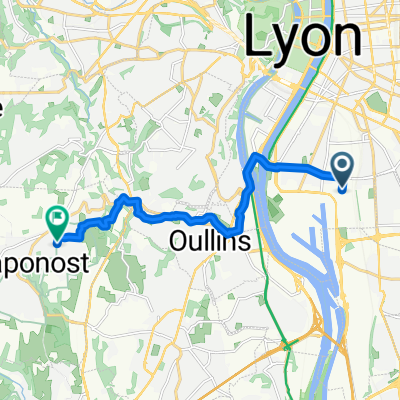
Chaponost-Carteret
A cycling route starting in Saint-Fons, Auvergne-Rhône-Alpes, France.
Overview
About this route
- -:--
- Duration
- 12.2 km
- Distance
- 207 m
- Ascent
- 41 m
- Descent
- ---
- Avg. speed
- ---
- Avg. speed

Route quality
Waytypes & surfaces along the route
Waytypes
Quiet road
4.1 km
(34 %)
Busy road
3.3 km
(27 %)
Surfaces
Paved
10.5 km
(86 %)
Unpaved
0.2 km
(2 %)
Asphalt
9.6 km
(79 %)
Concrete
0.4 km
(3 %)
Continue with Bikemap
Use, edit, or download this cycling route
You would like to ride Chaponost-Carteret or customize it for your own trip? Here is what you can do with this Bikemap route:
Free features
- Save this route as favorite or in collections
- Copy & plan your own version of this route
- Sync your route with Garmin or Wahoo
Premium features
Free trial for 3 days, or one-time payment. More about Bikemap Premium.
- Navigate this route on iOS & Android
- Export a GPX / KML file of this route
- Create your custom printout (try it for free)
- Download this route for offline navigation
Discover more Premium features.
Get Bikemap PremiumFrom our community
Other popular routes starting in Saint-Fons
 Maison-Travail
- Distance
- 5.3 km
- Ascent
- 16 m
- Descent
- 26 m
- Location
- Saint-Fons, Auvergne-Rhône-Alpes, France
 De Rue Jules Valensaut 44, Lyon à Avenue des Îles 18b, Saint-Maurice-de-Beynost
- Distance
- 18.1 km
- Ascent
- 39 m
- Descent
- 34 m
- Location
- Saint-Fons, Auvergne-Rhône-Alpes, France
 Chaponost-Carteret
- Distance
- 12.2 km
- Ascent
- 207 m
- Descent
- 41 m
- Location
- Saint-Fons, Auvergne-Rhône-Alpes, France
 Itinéraire à partir de 20 Rue Édouard Vaillant, Saint-Fons
- Distance
- 90.3 km
- Ascent
- 101 m
- Descent
- 128 m
- Location
- Saint-Fons, Auvergne-Rhône-Alpes, France
 Lyon - Genève
- Distance
- 184 km
- Ascent
- 1,171 m
- Descent
- 966 m
- Location
- Saint-Fons, Auvergne-Rhône-Alpes, France
 160 avenue Paul santy , Lyon à Rue Paul Gauguin, Meyzieu
- Distance
- 12.9 km
- Ascent
- 77 m
- Descent
- 65 m
- Location
- Saint-Fons, Auvergne-Rhône-Alpes, France
 Impasse Claude Jourdan, Lyon à Oullins-Pierre-Bénite
- Distance
- 11.2 km
- Ascent
- 94 m
- Descent
- 70 m
- Location
- Saint-Fons, Auvergne-Rhône-Alpes, France
 Itinéraire à partir de Rue Jules Valensaut 35, Lyon
- Distance
- 19 km
- Ascent
- 57 m
- Descent
- 65 m
- Location
- Saint-Fons, Auvergne-Rhône-Alpes, France
Open it in the app