

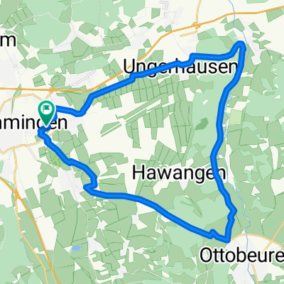
Allgäu - Benninger Ried und Günztal
A cycling route starting in Memmingen, Bavaria, Germany.
Overview
About this route
Aussichtsreiche Radtour und sehr abwechslungsreiche Rundfahrt mit mehreren kulturellen und landschaftlichen Höhepunkten; tw. auf bekannten Radwegen wie dem Günztal-Radweg und dem Kneipp-Radweg. (Tourbeschreibung unter: thod_er@gmx.de)
- -:--
- Duration
- 59 km
- Distance
- 537 m
- Ascent
- 537 m
- Descent
- ---
- Avg. speed
- ---
- Avg. speed
Route quality
Waytypes & surfaces along the route
Waytypes
Quiet road
32.9 km
(56 %)
Track
6.8 km
(12 %)
Surfaces
Paved
36.9 km
(63 %)
Unpaved
3.3 km
(6 %)
Asphalt
30.7 km
(52 %)
Paved (undefined)
6.1 km
(10 %)
Continue with Bikemap
Use, edit, or download this cycling route
You would like to ride Allgäu - Benninger Ried und Günztal or customize it for your own trip? Here is what you can do with this Bikemap route:
Free features
- Save this route as favorite or in collections
- Copy & plan your own version of this route
- Sync your route with Garmin or Wahoo
Premium features
Free trial for 3 days, or one-time payment. More about Bikemap Premium.
- Navigate this route on iOS & Android
- Export a GPX / KML file of this route
- Create your custom printout (try it for free)
- Download this route for offline navigation
Discover more Premium features.
Get Bikemap PremiumFrom our community
Other popular routes starting in Memmingen
 Von Memmingen bis Westerheim
- Distance
- 34.7 km
- Ascent
- 251 m
- Descent
- 251 m
- Location
- Memmingen, Bavaria, Germany
 MM-Rot-Schloss Zeil 60km
- Distance
- 55 km
- Ascent
- 352 m
- Descent
- 352 m
- Location
- Memmingen, Bavaria, Germany
 Geroldstraße 16, Memmingen to Geroldstraße 16, Memmingen
- Distance
- 27.6 km
- Ascent
- 1 m
- Descent
- 1 m
- Location
- Memmingen, Bavaria, Germany
 Memmingen-Kleinkallmünz
- Distance
- 65.2 km
- Ascent
- 298 m
- Descent
- 299 m
- Location
- Memmingen, Bavaria, Germany
 45_MM-Tannheim-Bonlanden-Fellheim-MM
- Distance
- 44.8 km
- Ascent
- 202 m
- Descent
- 201 m
- Location
- Memmingen, Bavaria, Germany
 Leichte MTB-Hausrunde
- Distance
- 37.9 km
- Ascent
- 303 m
- Descent
- 301 m
- Location
- Memmingen, Bavaria, Germany
 MM-Erolzheim-Rot
- Distance
- 56.4 km
- Ascent
- 271 m
- Descent
- 253 m
- Location
- Memmingen, Bavaria, Germany
 Memmingen-Kronburg
- Distance
- 57.7 km
- Ascent
- 340 m
- Descent
- 341 m
- Location
- Memmingen, Bavaria, Germany
Open it in the app