
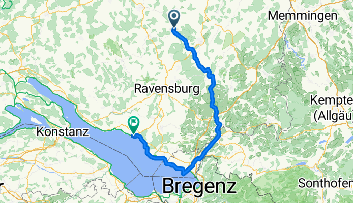
Aulendorf-Wangen-Lindau-(Dahlien)Friedrichshafen
A cycling route starting in Aulendorf, Baden-Württemberg, Germany.
Overview
About this route
Diese Radtour zweigt nördlich von Lindau bei Oberreitin ab zum privaten Dahliengarten. An die 800 verschieden Dahlien wachsen dort. Ein Farbenmeer an Blumen. (Tourbeschreibung unter: thod_er@gmx.de)
- -:--
- Duration
- 92.2 km
- Distance
- 917 m
- Ascent
- 1,060 m
- Descent
- ---
- Avg. speed
- ---
- Avg. speed
Route quality
Waytypes & surfaces along the route
Waytypes
Quiet road
47.3 km
(51 %)
Road
11.2 km
(12 %)
Surfaces
Paved
72.2 km
(78 %)
Unpaved
7.4 km
(8 %)
Asphalt
70 km
(76 %)
Loose gravel
3.9 km
(4 %)
Continue with Bikemap
Use, edit, or download this cycling route
You would like to ride Aulendorf-Wangen-Lindau-(Dahlien)Friedrichshafen or customize it for your own trip? Here is what you can do with this Bikemap route:
Free features
- Save this route as favorite or in collections
- Copy & plan your own version of this route
- Sync your route with Garmin or Wahoo
Premium features
Free trial for 3 days, or one-time payment. More about Bikemap Premium.
- Navigate this route on iOS & Android
- Export a GPX / KML file of this route
- Create your custom printout (try it for free)
- Download this route for offline navigation
Discover more Premium features.
Get Bikemap PremiumFrom our community
Other popular routes starting in Aulendorf
 Aulendorf - Markdorf über Fronreute - Horgenzell - Hefigkofen
- Distance
- 44.4 km
- Ascent
- 286 m
- Descent
- 428 m
- Location
- Aulendorf, Baden-Württemberg, Germany
 Allgäu - Oberschwaben Bäder-Rundtour
- Distance
- 56.3 km
- Ascent
- 577 m
- Descent
- 575 m
- Location
- Aulendorf, Baden-Württemberg, Germany
 Aulendorf - Bodensee - Rheinfall - Tübingen
- Distance
- 268.6 km
- Ascent
- 2,958 m
- Descent
- 3,155 m
- Location
- Aulendorf, Baden-Württemberg, Germany
 Unbenannte Route
- Distance
- 68 km
- Ascent
- 1,189 m
- Descent
- 1,350 m
- Location
- Aulendorf, Baden-Württemberg, Germany
 Woche 1 Steege
- Distance
- 5.5 km
- Ascent
- 46 m
- Descent
- 49 m
- Location
- Aulendorf, Baden-Württemberg, Germany
 Woche 3 - Elchenreuterweiher
- Distance
- 10.6 km
- Ascent
- 34 m
- Descent
- 33 m
- Location
- Aulendorf, Baden-Württemberg, Germany
 Von der Schussen an die Riß
- Distance
- 38.2 km
- Ascent
- 121 m
- Descent
- 121 m
- Location
- Aulendorf, Baden-Württemberg, Germany
 leider mit Steigung :-)
- Distance
- 2.4 km
- Ascent
- 118 m
- Descent
- 101 m
- Location
- Aulendorf, Baden-Württemberg, Germany
Open it in the app