
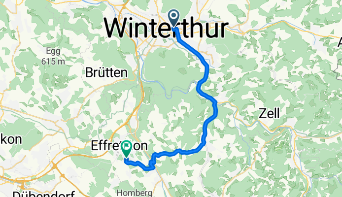
Winterthur - Weisslingen - Effretikon
A cycling route starting in Stadt Winterthur (Kreis 1) / Lind, Canton of Zurich, Switzerland.
Overview
About this route
- -:--
- Duration
- 17.6 km
- Distance
- 231 m
- Ascent
- 172 m
- Descent
- ---
- Avg. speed
- ---
- Avg. speed
Route quality
Waytypes & surfaces along the route
Waytypes
Road
7.1 km
(40 %)
Path
3.9 km
(22 %)
Surfaces
Paved
16.8 km
(95 %)
Unpaved
0.2 km
(1 %)
Asphalt
16.8 km
(95 %)
Gravel
0.2 km
(1 %)
Undefined
0.6 km
(3 %)
Continue with Bikemap
Use, edit, or download this cycling route
You would like to ride Winterthur - Weisslingen - Effretikon or customize it for your own trip? Here is what you can do with this Bikemap route:
Free features
- Save this route as favorite or in collections
- Copy & plan your own version of this route
- Sync your route with Garmin or Wahoo
Premium features
Free trial for 3 days, or one-time payment. More about Bikemap Premium.
- Navigate this route on iOS & Android
- Export a GPX / KML file of this route
- Create your custom printout (try it for free)
- Download this route for offline navigation
Discover more Premium features.
Get Bikemap PremiumFrom our community
Other popular routes starting in Stadt Winterthur (Kreis 1) / Lind
 bike to work
- Distance
- 32.7 km
- Ascent
- 332 m
- Descent
- 363 m
- Location
- Stadt Winterthur (Kreis 1) / Lind, Canton of Zurich, Switzerland
 Rundfahrt Tösstal
- Distance
- 50.9 km
- Ascent
- 630 m
- Descent
- 631 m
- Location
- Stadt Winterthur (Kreis 1) / Lind, Canton of Zurich, Switzerland
 Training Pikett INT
- Distance
- 2.5 km
- Ascent
- 71 m
- Descent
- 71 m
- Location
- Stadt Winterthur (Kreis 1) / Lind, Canton of Zurich, Switzerland
 Winti 1
- Distance
- 47.9 km
- Ascent
- 293 m
- Descent
- 305 m
- Location
- Stadt Winterthur (Kreis 1) / Lind, Canton of Zurich, Switzerland
 Winterthur Nord :: Thur 1
- Distance
- 38.6 km
- Ascent
- 252 m
- Descent
- 255 m
- Location
- Stadt Winterthur (Kreis 1) / Lind, Canton of Zurich, Switzerland
 Einfache Fahrt in Winterthur
- Distance
- 2.6 km
- Ascent
- 41 m
- Descent
- 40 m
- Location
- Stadt Winterthur (Kreis 1) / Lind, Canton of Zurich, Switzerland
 winti-Möriken
- Distance
- 57.7 km
- Ascent
- 488 m
- Descent
- 543 m
- Location
- Stadt Winterthur (Kreis 1) / Lind, Canton of Zurich, Switzerland
 DO Kyburg Bike
- Distance
- 21.1 km
- Ascent
- 432 m
- Descent
- 434 m
- Location
- Stadt Winterthur (Kreis 1) / Lind, Canton of Zurich, Switzerland
Open it in the app