

RTF Nordschwaben Rundfahrt 120 km
A cycling route starting in Höchstädt an der Donau, Bavaria, Germany.
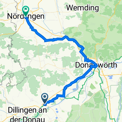
Overview
About this route
Das hier ist die RTF Nordschwaben Rundfahrt die 120 km Strecke. Abwechslungsreiche Strecke durch unterschiedlich lange aber nicht zu steile Anstiege. Landschaftlich schön, viele weite Ausblicke, meist verkehrsarme Abschnitte.
- -:--
- Duration
- 120.8 km
- Distance
- 862 m
- Ascent
- 863 m
- Descent
- ---
- Avg. speed
- ---
- Avg. speed
Route quality
Waytypes & surfaces along the route
Waytypes
Road
72.3 km
(60 %)
Quiet road
29.7 km
(25 %)
Surfaces
Paved
71.5 km
(59 %)
Asphalt
67.2 km
(56 %)
Paved (undefined)
4.2 km
(3 %)
Continue with Bikemap
Use, edit, or download this cycling route
You would like to ride RTF Nordschwaben Rundfahrt 120 km or customize it for your own trip? Here is what you can do with this Bikemap route:
Free features
- Save this route as favorite or in collections
- Copy & plan your own version of this route
- Sync your route with Garmin or Wahoo
Premium features
Free trial for 3 days, or one-time payment. More about Bikemap Premium.
- Navigate this route on iOS & Android
- Export a GPX / KML file of this route
- Create your custom printout (try it for free)
- Download this route for offline navigation
Discover more Premium features.
Get Bikemap PremiumFrom our community
Other popular routes starting in Höchstädt an der Donau
 UT 05-2023: Höchstädt a.d. Donau - Nördlingen
- Distance
- 56.9 km
- Ascent
- 322 m
- Descent
- 302 m
- Location
- Höchstädt an der Donau, Bavaria, Germany
 D08 Höchstädt - Neuburg
- Distance
- 72.3 km
- Ascent
- 236 m
- Descent
- 278 m
- Location
- Höchstädt an der Donau, Bavaria, Germany
 Höchstädt an der Donau / Ingolstadt, Allemagne du 22 au 23
- Distance
- 90.6 km
- Ascent
- 140 m
- Descent
- 199 m
- Location
- Höchstädt an der Donau, Bavaria, Germany
 Donau6 Höchstädt-Neuburg
- Distance
- 64.5 km
- Ascent
- 180 m
- Descent
- 217 m
- Location
- Höchstädt an der Donau, Bavaria, Germany
 Höchstädt - Katzenstein
- Distance
- 58.3 km
- Ascent
- 0 m
- Descent
- 0 m
- Location
- Höchstädt an der Donau, Bavaria, Germany
 Radtour 2023 - 10. Tag
- Distance
- 28.3 km
- Ascent
- 40 m
- Descent
- 54 m
- Location
- Höchstädt an der Donau, Bavaria, Germany
 201405-04 Iller - Donau - Zusam Höchstädt - Zusam - Markt Wald
- Distance
- 75.1 km
- Ascent
- 428 m
- Descent
- 214 m
- Location
- Höchstädt an der Donau, Bavaria, Germany
 Zügle - Wertingen-Mertingen
- Distance
- 63.1 km
- Ascent
- 8,820 m
- Descent
- 9,240 m
- Location
- Höchstädt an der Donau, Bavaria, Germany
Open it in the app