

Weinberg-Strecke MTB
A cycling route starting in Klosterneuburg, Lower Austria, Austria.
Overview
About this route
Quelle: Mountainbiketour ausgehend von Klosterneuburg, Camping.
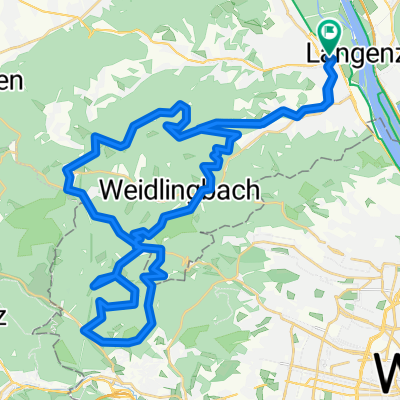
Klosterneuburg - Buchberg - Hohenauer Wiese - Weidling - Klosterneuburg.
Schwierigkeit: mittel
Strecke: 17,06 km
Aufstieg: 329 Hm
Abstieg: 329 Hm
Dauer: 1:35 h
Niedrigster Punkt: 162 m
Höchster Punkt: 392 m
- -:--
- Duration
- 17.1 km
- Distance
- 322 m
- Ascent
- 324 m
- Descent
- ---
- Avg. speed
- ---
- Avg. speed

Route quality
Waytypes & surfaces along the route
Waytypes
Track
8.4 km
(49 %)
Quiet road
6.1 km
(36 %)
Surfaces
Paved
5.7 km
(34 %)
Unpaved
7.2 km
(42 %)
Gravel
6.6 km
(39 %)
Asphalt
4.7 km
(27 %)
Continue with Bikemap
Use, edit, or download this cycling route
You would like to ride Weinberg-Strecke MTB or customize it for your own trip? Here is what you can do with this Bikemap route:
Free features
- Save this route as favorite or in collections
- Copy & plan your own version of this route
- Sync your route with Garmin or Wahoo
Premium features
Free trial for 3 days, or one-time payment. More about Bikemap Premium.
- Navigate this route on iOS & Android
- Export a GPX / KML file of this route
- Create your custom printout (try it for free)
- Download this route for offline navigation
Discover more Premium features.
Get Bikemap PremiumFrom our community
Other popular routes starting in Klosterneuburg
 AUT KLBG-Dopplerhütte-Greifenstein-Weinviertel-KLBG
- Distance
- 68.8 km
- Ascent
- 652 m
- Descent
- 661 m
- Location
- Klosterneuburg, Lower Austria, Austria
 Klosterneuburg Loudonsche Türkensteine Mostalm
- Distance
- 51.2 km
- Ascent
- 913 m
- Descent
- 913 m
- Location
- Klosterneuburg, Lower Austria, Austria
 Klosterneuburg/Weidling - Nordbrücke - Greifenstein - Hadersfeld - Klosterneuburg/Weidling
- Distance
- 40.7 km
- Ascent
- 369 m
- Descent
- 368 m
- Location
- Klosterneuburg, Lower Austria, Austria
 Babenbergerstrecke bis Windischhütte
- Distance
- 18.4 km
- Ascent
- 442 m
- Descent
- 442 m
- Location
- Klosterneuburg, Lower Austria, Austria
 Höhenstraßen - Marathon (Wien)
- Distance
- 95.2 km
- Ascent
- 2,035 m
- Descent
- 1,947 m
- Location
- Klosterneuburg, Lower Austria, Austria
 Weidling - Rieglerhütte - Weidling
- Distance
- 24 km
- Ascent
- 684 m
- Descent
- 685 m
- Location
- Klosterneuburg, Lower Austria, Austria
 120_Donauinsel-Kreutal-Spannberg-Donauinsel
- Distance
- 119.8 km
- Ascent
- 393 m
- Descent
- 403 m
- Location
- Klosterneuburg, Lower Austria, Austria
 KLBG-Tulln-Kreuzenstein
- Distance
- 83.3 km
- Ascent
- 690 m
- Descent
- 700 m
- Location
- Klosterneuburg, Lower Austria, Austria
Open it in the app