

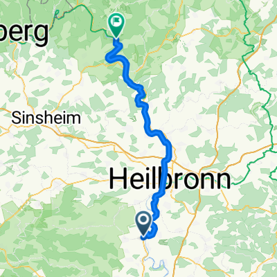
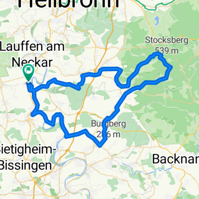
Zaberfelder See 2020-03-16 11:55
A cycling route starting in Kirchheim am Neckar, Baden-Württemberg, Germany.
Overview
About this route
Startzeit: 11:55 16.03.2020 Zielzeit: 16:30 16.03.2020 Strecke: 46,6 km (04:35) Bewegungszeit: 02:11 Ø-Geschwindigkeit: 10,17 km/h Netto-Geschwindigkeit: 21,26 km/h Max. Geschwindigkeit: 39,8 km/h Minimale Höhe: 172 m Maximale Höhe: 437 m Steig-Geschw.: 388,1 m/h Sink-Geschw.: -187,6 m/h Aufstieg: 567 m Abstieg: -572 m Steigzeit: 01:27 Sinkzeit: 03:03
- -:--
- Duration
- 46.2 km
- Distance
- 483 m
- Ascent
- 485 m
- Descent
- ---
- Avg. speed
- ---
- Avg. speed

Route quality
Waytypes & surfaces along the route
Waytypes
Track
26.9 km
(58 %)
Quiet road
7.2 km
(16 %)
Surfaces
Paved
31.2 km
(68 %)
Unpaved
12.4 km
(27 %)
Asphalt
28 km
(61 %)
Gravel
8.9 km
(19 %)
Continue with Bikemap
Use, edit, or download this cycling route
You would like to ride Zaberfelder See 2020-03-16 11:55 or customize it for your own trip? Here is what you can do with this Bikemap route:
Free features
- Save this route as favorite or in collections
- Copy & plan your own version of this route
- Sync your route with Garmin or Wahoo
Premium features
Free trial for 3 days, or one-time payment. More about Bikemap Premium.
- Navigate this route on iOS & Android
- Export a GPX / KML file of this route
- Create your custom printout (try it for free)
- Download this route for offline navigation
Discover more Premium features.
Get Bikemap PremiumFrom our community
Other popular routes starting in Kirchheim am Neckar
 Taubenweg 5, Kirchheim am Neckar nach Taubenweg 6, Kirchheim am Neckar
- Distance
- 20 km
- Ascent
- 122 m
- Descent
- 120 m
- Location
- Kirchheim am Neckar, Baden-Württemberg, Germany
 Tag 5: Kirchheim bis Neckargerach
- Distance
- 60.6 km
- Ascent
- 188 m
- Descent
- 226 m
- Location
- Kirchheim am Neckar, Baden-Württemberg, Germany
 Zaberfelder See 2020-03-16 11:55
- Distance
- 46.2 km
- Ascent
- 483 m
- Descent
- 485 m
- Location
- Kirchheim am Neckar, Baden-Württemberg, Germany
 Kirchheim - Löchgau - Bietigheim - Besigheim
- Distance
- 32.3 km
- Ascent
- 264 m
- Descent
- 267 m
- Location
- Kirchheim am Neckar, Baden-Württemberg, Germany
 Kirchheim - Prevorst - Beilstein - Kirchheim
- Distance
- 68.3 km
- Ascent
- 752 m
- Descent
- 694 m
- Location
- Kirchheim am Neckar, Baden-Württemberg, Germany
 Jogging Hausrunde
- Distance
- 5.2 km
- Ascent
- 37 m
- Descent
- 39 m
- Location
- Kirchheim am Neckar, Baden-Württemberg, Germany
 ADFC-Kirchheim Tour 1
- Distance
- 19.7 km
- Ascent
- 74 m
- Descent
- 78 m
- Location
- Kirchheim am Neckar, Baden-Württemberg, Germany
 Neckartal-Radweg von Kirchheim nach Gundelsheim
- Distance
- 40.1 km
- Ascent
- 160 m
- Descent
- 188 m
- Location
- Kirchheim am Neckar, Baden-Württemberg, Germany
Open it in the app