

【徹底解剖その3】B.B.BASEのモデルコースをご紹介します!_外房(安房鴨川)コース(ロングコース)
A cycling route starting in Kamogawa, Chiba, Japan.
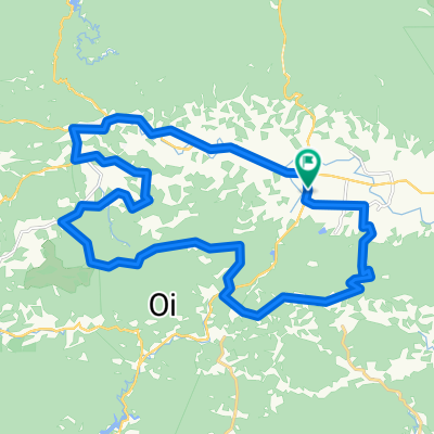
Overview
About this route
- -:--
- Duration
- 80.3 km
- Distance
- 1,124 m
- Ascent
- 1,123 m
- Descent
- ---
- Avg. speed
- ---
- Max. altitude

Route quality
Waytypes & surfaces along the route
Waytypes
Road
25.7 km
(32 %)
Quiet road
19.3 km
(24 %)
Surfaces
Paved
20.1 km
(25 %)
Asphalt
18.5 km
(23 %)
Paved (undefined)
1.6 km
(2 %)
Undefined
60.2 km
(75 %)
Continue with Bikemap
Use, edit, or download this cycling route
You would like to ride 【徹底解剖その3】B.B.BASEのモデルコースをご紹介します!_外房(安房鴨川)コース(ロングコース) or customize it for your own trip? Here is what you can do with this Bikemap route:
Free features
- Save this route as favorite or in collections
- Copy & plan your own version of this route
- Split it into stages to create a multi-day tour
- Sync your route with Garmin or Wahoo
Premium features
Free trial for 3 days, or one-time payment. More about Bikemap Premium.
- Navigate this route on iOS & Android
- Export a GPX / KML file of this route
- Create your custom printout (try it for free)
- Download this route for offline navigation
Discover more Premium features.
Get Bikemap PremiumFrom our community
Other popular routes starting in Kamogawa
 BAC-AwaKamogawa-BnH
- Distance
- 45.2 km
- Ascent
- 481 m
- Descent
- 481 m
- Location
- Kamogawa, Chiba, Japan
 BR-Minaminosato-HamaKanaya
- Distance
- 29.5 km
- Ascent
- 551 m
- Descent
- 595 m
- Location
- Kamogawa, Chiba, Japan
 Boso-Oyama-Mineoka
- Distance
- 30.5 km
- Ascent
- 608 m
- Descent
- 606 m
- Location
- Kamogawa, Chiba, Japan
 BR-Minaminosato-Chikura
- Distance
- 23.2 km
- Ascent
- 234 m
- Descent
- 264 m
- Location
- Kamogawa, Chiba, Japan
 BR-Minaminosato-Tateyama
- Distance
- 67.5 km
- Ascent
- 277 m
- Descent
- 323 m
- Location
- Kamogawa, Chiba, Japan
 Boso Risde Day 2 June '17
- Distance
- 81.9 km
- Ascent
- 1,078 m
- Descent
- 978 m
- Location
- Kamogawa, Chiba, Japan
 Boso S3: Awa Kamogawa - Heguri - Hota
- Distance
- 61.4 km
- Ascent
- 371 m
- Descent
- 372 m
- Location
- Kamogawa, Chiba, Japan
 Boso S3: Awa Kamogawa - Kanaya
- Distance
- 92.7 km
- Ascent
- 218 m
- Descent
- 220 m
- Location
- Kamogawa, Chiba, Japan
Open it in the app