

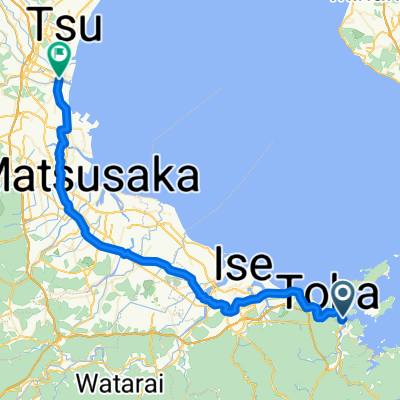
【三重県】太平洋岸自転車道の三重県区間!山あり海ありの紀勢地域とは!?_鳥羽駅~紀伊長島駅(海ルート)
A cycling route starting in Toba, Mie, Japan.
Overview
About this route
- -:--
- Duration
- 112.9 km
- Distance
- 4,821 m
- Ascent
- 4,819 m
- Descent
- ---
- Avg. speed
- ---
- Avg. speed

Continue with Bikemap
Use, edit, or download this cycling route
You would like to ride 【三重県】太平洋岸自転車道の三重県区間!山あり海ありの紀勢地域とは!?_鳥羽駅~紀伊長島駅(海ルート) or customize it for your own trip? Here is what you can do with this Bikemap route:
Free features
- Save this route as favorite or in collections
- Copy & plan your own version of this route
- Sync your route with Garmin or Wahoo
Premium features
Free trial for 3 days, or one-time payment. More about Bikemap Premium.
- Navigate this route on iOS & Android
- Export a GPX / KML file of this route
- Create your custom printout (try it for free)
- Download this route for offline navigation
Discover more Premium features.
Get Bikemap PremiumFrom our community
Other popular routes starting in Toba
 2021.12.27 00:31:55
- Distance
- 111 km
- Ascent
- 1,513 m
- Descent
- 1,516 m
- Location
- Toba, Mie, Japan
 Phase 8 (and 7 alt)
- Distance
- 151.6 km
- Ascent
- 465 m
- Descent
- 438 m
- Location
- Toba, Mie, Japan
 CJ06 鳥羽~津(2016)
- Distance
- 48.8 km
- Ascent
- 82 m
- Descent
- 85 m
- Location
- Toba, Mie, Japan
 Phase 7
- Distance
- 78.9 km
- Ascent
- 410 m
- Descent
- 362 m
- Location
- Toba, Mie, Japan
 Xipangu 2
- Distance
- 1,129.6 km
- Ascent
- 1,851 m
- Descent
- 1,850 m
- Location
- Toba, Mie, Japan
 2016Tour-Toba
- Distance
- 74.5 km
- Ascent
- 192 m
- Descent
- 116 m
- Location
- Toba, Mie, Japan
 Length of Japan Toba-Tsu
- Distance
- 57.8 km
- Ascent
- 79 m
- Descent
- 81 m
- Location
- Toba, Mie, Japan
 5: Toba to Kyoto
- Distance
- 151.7 km
- Ascent
- 465 m
- Descent
- 438 m
- Location
- Toba, Mie, Japan
Open it in the app