

輕鬆騎行 南區
A cycling route starting in Taichung, Taiwan, Taiwan.
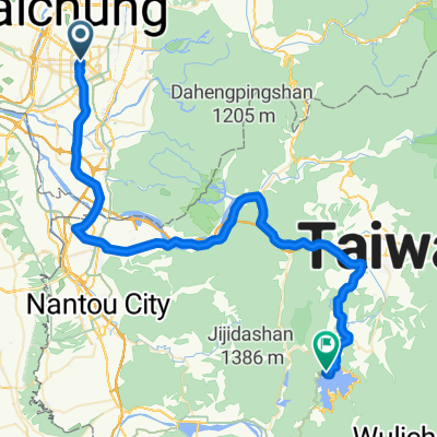
Overview
About this route
- 26 min
- Duration
- 5.1 km
- Distance
- 280 m
- Ascent
- 289 m
- Descent
- 11.6 km/h
- Avg. speed
- ---
- Avg. speed

Continue with Bikemap
Use, edit, or download this cycling route
You would like to ride 輕鬆騎行 南區 or customize it for your own trip? Here is what you can do with this Bikemap route:
Free features
- Save this route as favorite or in collections
- Copy & plan your own version of this route
- Sync your route with Garmin or Wahoo
Premium features
Free trial for 3 days, or one-time payment. More about Bikemap Premium.
- Navigate this route on iOS & Android
- Export a GPX / KML file of this route
- Create your custom printout (try it for free)
- Download this route for offline navigation
Discover more Premium features.
Get Bikemap PremiumFrom our community
Other popular routes starting in Taichung
 日月潭 平易近人 路線
- Distance
- 149.1 km
- Ascent
- 1,064 m
- Descent
- 1,062 m
- Location
- Taichung, Taiwan, Taiwan
 傳說中的136
- Distance
- 19.2 km
- Ascent
- 997 m
- Descent
- 961 m
- Location
- Taichung, Taiwan, Taiwan
 太平_老鼠崎
- Distance
- 8.4 km
- Ascent
- 473 m
- Descent
- 457 m
- Location
- Taichung, Taiwan, Taiwan
 136
136- Distance
- 19.3 km
- Ascent
- 754 m
- Descent
- 297 m
- Location
- Taichung, Taiwan, Taiwan
 華盛頓中學_四方太子宮
- Distance
- 5.7 km
- Ascent
- 345 m
- Descent
- 151 m
- Location
- Taichung, Taiwan, Taiwan
 環島路線-海線
- Distance
- 1,073 km
- Ascent
- 1,095 m
- Descent
- 1,095 m
- Location
- Taichung, Taiwan, Taiwan
 中興嶺 : 廍子路 to 中興嶺郵局
- Distance
- 10.9 km
- Ascent
- 486 m
- Descent
- 115 m
- Location
- Taichung, Taiwan, Taiwan
 台中-日月潭
- Distance
- 72.4 km
- Ascent
- 1,089 m
- Descent
- 559 m
- Location
- Taichung, Taiwan, Taiwan
Open it in the app