

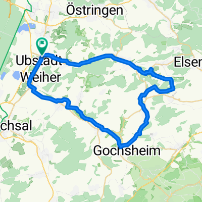
Ubstadt nach Menzingen
A cycling route starting in Ubstadt-Weiher, Baden-Württemberg, Germany.
Overview
About this route
Ubstadt-Unteröwisheim-Münzesheim-Gochsheim-Bahnbrücken-Menzingen. Zurück die gleiche Strecke oder mit der S-Bahn. Dauer mit dem Rad ca. 60 min. (ohne Pausen). Die Strecke hat nur leichte Steigungen.
- -:--
- Duration
- 17 km
- Distance
- 97 m
- Ascent
- 41 m
- Descent
- ---
- Avg. speed
- 181 m
- Avg. speed
Route quality
Waytypes & surfaces along the route
Waytypes
Track
6 km
(36 %)
Quiet road
5 km
(30 %)
Surfaces
Paved
11.8 km
(70 %)
Unpaved
4.8 km
(29 %)
Asphalt
10.3 km
(60 %)
Loose gravel
2.8 km
(17 %)
Continue with Bikemap
Use, edit, or download this cycling route
You would like to ride Ubstadt nach Menzingen or customize it for your own trip? Here is what you can do with this Bikemap route:
Free features
- Save this route as favorite or in collections
- Copy & plan your own version of this route
- Sync your route with Garmin or Wahoo
Premium features
Free trial for 3 days, or one-time payment. More about Bikemap Premium.
- Navigate this route on iOS & Android
- Export a GPX / KML file of this route
- Create your custom printout (try it for free)
- Download this route for offline navigation
Discover more Premium features.
Get Bikemap PremiumFrom our community
Other popular routes starting in Ubstadt-Weiher
 Weiher - Kraichgau - Weiher
- Distance
- 47.6 km
- Ascent
- 453 m
- Descent
- 444 m
- Location
- Ubstadt-Weiher, Baden-Württemberg, Germany
 Challenge Kraichgau 2009
- Distance
- 89.3 km
- Ascent
- 959 m
- Descent
- 875 m
- Location
- Ubstadt-Weiher, Baden-Württemberg, Germany
 Flache Rundtour Stettfeld-Münzesheim-Menzingen-Odenheim
- Distance
- 40.1 km
- Ascent
- 154 m
- Descent
- 156 m
- Location
- Ubstadt-Weiher, Baden-Württemberg, Germany
 Kleine Kraichgaurunde
- Distance
- 27.8 km
- Ascent
- 475 m
- Descent
- 490 m
- Location
- Ubstadt-Weiher, Baden-Württemberg, Germany
 Ubstadt (Kraichtal) zum Wasserscholss Menzingen am Kraichbach entlang
- Distance
- 17.7 km
- Ascent
- 73 m
- Descent
- 17 m
- Location
- Ubstadt-Weiher, Baden-Württemberg, Germany
 Gravel Mingolsheim - Östringen - Odenheim
- Distance
- 39.8 km
- Ascent
- 454 m
- Descent
- 457 m
- Location
- Ubstadt-Weiher, Baden-Württemberg, Germany
 Rund um den Schmallenberg
- Distance
- 20.1 km
- Ascent
- 148 m
- Descent
- 151 m
- Location
- Ubstadt-Weiher, Baden-Württemberg, Germany
 Ubstadt Weiher, 3 Bäche Tour
- Distance
- 39.1 km
- Ascent
- 156 m
- Descent
- 178 m
- Location
- Ubstadt-Weiher, Baden-Württemberg, Germany
Open it in the app