
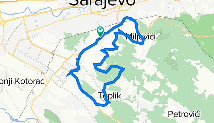
Preko Križa, Toplika, Kadinih voda, Ivanića, Miljevića
A cycling route starting in Sarajevo, Federation of Bosnia and Herzegovina, Bosnia and Herzegovina.
Overview
About this route
Lukavica - Pavlovac - Križ - Toplik - Kadine vode - Ivanići - Prljevo brdo - Miljevići - Vraca -lukavica
- -:--
- Duration
- 17.7 km
- Distance
- 390 m
- Ascent
- 390 m
- Descent
- ---
- Avg. speed
- ---
- Avg. speed

Route quality
Waytypes & surfaces along the route
Waytypes
Busy road
7.4 km
(42 %)
Quiet road
5 km
(28 %)
Surfaces
Paved
13.1 km
(74 %)
Unpaved
2.4 km
(14 %)
Asphalt
13.1 km
(74 %)
Ground
2.3 km
(13 %)
Continue with Bikemap
Use, edit, or download this cycling route
You would like to ride Preko Križa, Toplika, Kadinih voda, Ivanića, Miljevića or customize it for your own trip? Here is what you can do with this Bikemap route:
Free features
- Save this route as favorite or in collections
- Copy & plan your own version of this route
- Sync your route with Garmin or Wahoo
Premium features
Free trial for 3 days, or one-time payment. More about Bikemap Premium.
- Navigate this route on iOS & Android
- Export a GPX / KML file of this route
- Create your custom printout (try it for free)
- Download this route for offline navigation
Discover more Premium features.
Get Bikemap PremiumFrom our community
Other popular routes starting in Sarajevo
 h stan
- Distance
- 16.4 km
- Ascent
- 943 m
- Descent
- 131 m
- Location
- Sarajevo, Federation of Bosnia and Herzegovina, Bosnia and Herzegovina
 From Sarajevo to Visoko
- Distance
- 55.3 km
- Ascent
- 1,350 m
- Descent
- 1,441 m
- Location
- Sarajevo, Federation of Bosnia and Herzegovina, Bosnia and Herzegovina
 Alpasino - Krupac - Dejcici - Trnovo - Dobrinja
- Distance
- 69.4 km
- Ascent
- 909 m
- Descent
- 919 m
- Location
- Sarajevo, Federation of Bosnia and Herzegovina, Bosnia and Herzegovina
 Hilandarska 36, Lukavica to Hilandarska 20, Lukavica
- Distance
- 30.5 km
- Ascent
- 264 m
- Descent
- 263 m
- Location
- Sarajevo, Federation of Bosnia and Herzegovina, Bosnia and Herzegovina
 Ive Andrića 17c to Ive Andrića 19j, Sarajevo
- Distance
- 35.8 km
- Ascent
- 181 m
- Descent
- 174 m
- Location
- Sarajevo, Federation of Bosnia and Herzegovina, Bosnia and Herzegovina
 Vraca - Brus - Tilava - Dobrinja
- Distance
- 34.2 km
- Ascent
- 1,289 m
- Descent
- 1,208 m
- Location
- Sarajevo, Federation of Bosnia and Herzegovina, Bosnia and Herzegovina
 Lukavica_Kasindol_Klanac_Lukavica
- Distance
- 32.3 km
- Ascent
- 775 m
- Descent
- 769 m
- Location
- Sarajevo, Federation of Bosnia and Herzegovina, Bosnia and Herzegovina
 Pofalići - Hum repetitor
- Distance
- 5.6 km
- Ascent
- 299 m
- Descent
- 15 m
- Location
- Sarajevo, Federation of Bosnia and Herzegovina, Bosnia and Herzegovina
Open it in the app