

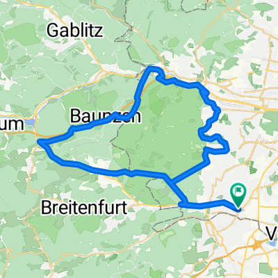
Hochroterd - Gruberau - Heiligenkreuz - Pfaffstätten - Mödling - Giesshübl
A cycling route starting in Perchtoldsdorf, Lower Austria, Austria.
Overview
About this route
Der Beginn von Rodaun nach Hochroterd ist sehr steil - dann geht es locker bis nach Heiligenkreuz; dort die steile B11 hinauf, runter nach Gaaden, rauf nach Einöd/Pfaffstätten, über Gumpoldskrichen runter nach Mödling und den sehr steilen Schluss-Anstieg nach Gießhübl.
- -:--
- Duration
- 59.4 km
- Distance
- 702 m
- Ascent
- 702 m
- Descent
- ---
- Avg. speed
- ---
- Avg. speed
Route quality
Waytypes & surfaces along the route
Waytypes
Busy road
42.5 km
(72 %)
Road
6.7 km
(11 %)
Surfaces
Paved
53.3 km
(90 %)
Unpaved
0.1 km
(<1 %)
Asphalt
51.8 km
(87 %)
Concrete
1.5 km
(3 %)
Continue with Bikemap
Use, edit, or download this cycling route
You would like to ride Hochroterd - Gruberau - Heiligenkreuz - Pfaffstätten - Mödling - Giesshübl or customize it for your own trip? Here is what you can do with this Bikemap route:
Free features
- Save this route as favorite or in collections
- Copy & plan your own version of this route
- Sync your route with Garmin or Wahoo
Premium features
Free trial for 3 days, or one-time payment. More about Bikemap Premium.
- Navigate this route on iOS & Android
- Export a GPX / KML file of this route
- Create your custom printout (try it for free)
- Download this route for offline navigation
Discover more Premium features.
Get Bikemap PremiumFrom our community
Other popular routes starting in Perchtoldsdorf
 Liesing/Wienerwald-Runde
- Distance
- 42 km
- Ascent
- 534 m
- Descent
- 505 m
- Location
- Perchtoldsdorf, Lower Austria, Austria
 Große Runde um den lainzer Tierpark
- Distance
- 43.2 km
- Ascent
- 518 m
- Descent
- 514 m
- Location
- Perchtoldsdorf, Lower Austria, Austria
 Parapulie Strecke
- Distance
- 32 km
- Ascent
- 723 m
- Descent
- 723 m
- Location
- Perchtoldsdorf, Lower Austria, Austria
 Liesing - Hütteldorf
- Distance
- 15.9 km
- Ascent
- 293 m
- Descent
- 303 m
- Location
- Perchtoldsdorf, Lower Austria, Austria
 Rodaun - Laab/Kloster
- Distance
- 17.5 km
- Ascent
- 199 m
- Descent
- 196 m
- Location
- Perchtoldsdorf, Lower Austria, Austria
 Wienerwald-Schmankerl
- Distance
- 44.3 km
- Ascent
- 723 m
- Descent
- 721 m
- Location
- Perchtoldsdorf, Lower Austria, Austria
 Einkaufen 🍦🍘
- Distance
- 1.1 km
- Ascent
- 4 m
- Descent
- 4 m
- Location
- Perchtoldsdorf, Lower Austria, Austria
 Lainzer Tiergarten Runde
- Distance
- 31.9 km
- Ascent
- 627 m
- Descent
- 627 m
- Location
- Perchtoldsdorf, Lower Austria, Austria
Open it in the app