
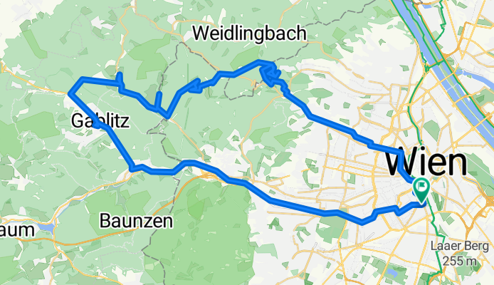
Hameau - Sophienalpe - Mauerbach - Gablitz - Purkersdorf
A cycling route starting in Vienna, Vienna, Austria.
Overview
About this route
- -:--
- Duration
- 56.5 km
- Distance
- 488 m
- Ascent
- 490 m
- Descent
- ---
- Avg. speed
- ---
- Avg. speed

Route quality
Waytypes & surfaces along the route
Waytypes
Busy road
12.4 km
(22 %)
Road
9.4 km
(17 %)
Surfaces
Paved
42.3 km
(75 %)
Unpaved
6.7 km
(12 %)
Asphalt
35.3 km
(62 %)
Concrete
4.6 km
(8 %)
Route highlights
Points of interest along the route
Point of interest after 11.5 km
bisschen verfahren hier... bitte geradeaus weiter :)
Point of interest after 16 km
Hameau
Point of interest after 19.4 km
Sophienalpe
Point of interest after 25.3 km
Kirche Maria Rast
Point of interest after 28.9 km
Kartause Mauerbach
Drinking water after 33.4 km
alter Trinkwasserbrunnen für Wanderer
Point of interest after 35.2 km
Gablitz
Point of interest after 38.2 km
Purkersdorf
Continue with Bikemap
Use, edit, or download this cycling route
You would like to ride Hameau - Sophienalpe - Mauerbach - Gablitz - Purkersdorf or customize it for your own trip? Here is what you can do with this Bikemap route:
Free features
- Save this route as favorite or in collections
- Copy & plan your own version of this route
- Sync your route with Garmin or Wahoo
Premium features
Free trial for 3 days, or one-time payment. More about Bikemap Premium.
- Navigate this route on iOS & Android
- Export a GPX / KML file of this route
- Create your custom printout (try it for free)
- Download this route for offline navigation
Discover more Premium features.
Get Bikemap PremiumFrom our community
Other popular routes starting in Vienna
 Augustiner- u Mostalmtrail über Sophienalpe
- Distance
- 32.1 km
- Ascent
- 540 m
- Descent
- 534 m
- Location
- Vienna, Vienna, Austria
 Donau-Radweg: Wien-Bratislava
- Distance
- 70.9 km
- Ascent
- 332 m
- Descent
- 340 m
- Location
- Vienna, Vienna, Austria
 Boku-Exelberg-Sophie-Riederb-TulbingK-Königstetten-St-Andrae-Hintersd-Boku
- Distance
- 84.2 km
- Ascent
- 1,189 m
- Descent
- 1,189 m
- Location
- Vienna, Vienna, Austria
 Summer Event
- Distance
- 31.4 km
- Ascent
- 186 m
- Descent
- 185 m
- Location
- Vienna, Vienna, Austria
 Naschmarkt/Klosterneuburg/St. Andrä/Exelberg
- Distance
- 58.1 km
- Ascent
- 481 m
- Descent
- 481 m
- Location
- Vienna, Vienna, Austria
 Wien - Neusiedl am See (La Primavera Austria)
- Distance
- 116.4 km
- Ascent
- 287 m
- Descent
- 287 m
- Location
- Vienna, Vienna, Austria
 Blaue Leberkäsrunde: Donau-Prater(wirt)
- Distance
- 27.5 km
- Ascent
- 168 m
- Descent
- 180 m
- Location
- Vienna, Vienna, Austria
 Wien - Haslau an der Donau - Kittsee - Wien
- Distance
- 138.3 km
- Ascent
- 371 m
- Descent
- 423 m
- Location
- Vienna, Vienna, Austria
Open it in the app