

Bähnle Radweg bis Stühlingen
A cycling route starting in Hinterzarten, Baden-Württemberg, Germany.
Overview
About this route
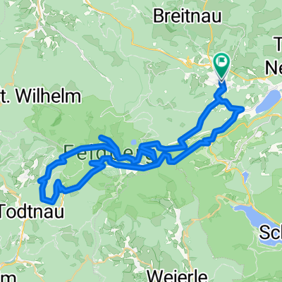
Bähnle Radweg - Titisee Neustadt - Lenzkirch - Bonndorf
- -:--
- Duration
- 47.1 km
- Distance
- 316 m
- Ascent
- 718 m
- Descent
- ---
- Avg. speed
- ---
- Avg. speed

Continue with Bikemap
Use, edit, or download this cycling route
You would like to ride Bähnle Radweg bis Stühlingen or customize it for your own trip? Here is what you can do with this Bikemap route:
Free features
- Save this route as favorite or in collections
- Copy & plan your own version of this route
- Sync your route with Garmin or Wahoo
Premium features
Free trial for 3 days, or one-time payment. More about Bikemap Premium.
- Navigate this route on iOS & Android
- Export a GPX / KML file of this route
- Create your custom printout (try it for free)
- Download this route for offline navigation
Discover more Premium features.
Get Bikemap PremiumFrom our community
Other popular routes starting in Hinterzarten
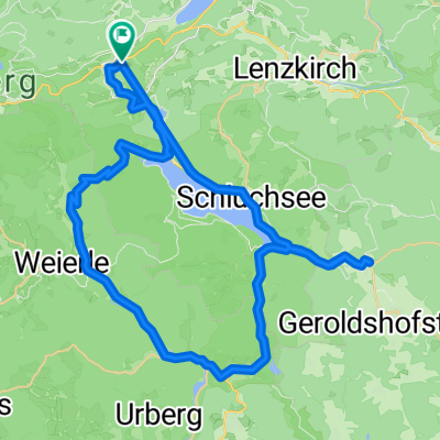
 Titisee - Schluchsee
- Distance
- 46.1 km
- Ascent
- 1,002 m
- Descent
- 1,019 m
- Location
- Hinterzarten, Baden-Württemberg, Germany
 Black Forest Ultra Bike 42km
- Distance
- 40.1 km
- Ascent
- 753 m
- Descent
- 1,290 m
- Location
- Hinterzarten, Baden-Württemberg, Germany
 Radfahren 24.07.2008
- Distance
- 105.5 km
- Ascent
- 1,548 m
- Descent
- 1,552 m
- Location
- Hinterzarten, Baden-Württemberg, Germany
 Rund um den Feldberg ...
- Distance
- 47.2 km
- Ascent
- 1,274 m
- Descent
- 1,273 m
- Location
- Hinterzarten, Baden-Württemberg, Germany
 Bärental, Schluchsee, Rothaus, Bonndorf, Lenzkirch, Bärental
- Distance
- 55.7 km
- Ascent
- 617 m
- Descent
- 617 m
- Location
- Hinterzarten, Baden-Württemberg, Germany
 Südschwarzwald-Radweg
- Distance
- 266.4 km
- Ascent
- 1,219 m
- Descent
- 1,219 m
- Location
- Hinterzarten, Baden-Württemberg, Germany
 Radfahren 22.07.2008
- Distance
- 53.2 km
- Ascent
- 713 m
- Descent
- 722 m
- Location
- Hinterzarten, Baden-Württemberg, Germany
 Titisee 1
- Distance
- 18.2 km
- Ascent
- 366 m
- Descent
- 366 m
- Location
- Hinterzarten, Baden-Württemberg, Germany
Open it in the app