

49-193 loop
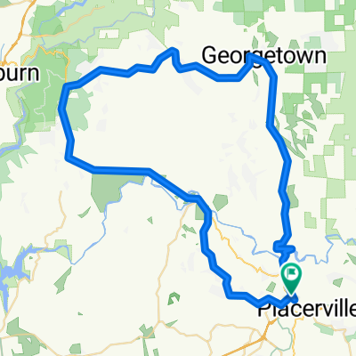
A cycling route starting in Placerville, California, United States of America.
Overview
About this route
- -:--
- Duration
- 75.3 km
- Distance
- 1,171 m
- Ascent
- 1,171 m
- Descent
- ---
- Avg. speed
- ---
- Avg. speed

Route quality
Waytypes & surfaces along the route
Waytypes
Busy road
59.8 km
(79 %)
Road
13.5 km
(18 %)
Surfaces
Paved
60.2 km
(80 %)
Asphalt
54.1 km
(72 %)
Paved (undefined)
6.1 km
(8 %)
Continue with Bikemap
Use, edit, or download this cycling route
You would like to ride 49-193 loop or customize it for your own trip? Here is what you can do with this Bikemap route:
Free features
- Save this route as favorite or in collections
- Copy & plan your own version of this route
- Sync your route with Garmin or Wahoo
Premium features
Free trial for 3 days, or one-time payment. More about Bikemap Premium.
- Navigate this route on iOS & Android
- Export a GPX / KML file of this route
- Create your custom printout (try it for free)
- Download this route for offline navigation
Discover more Premium features.
Get Bikemap PremiumFrom our community
Other popular routes starting in Placerville
 49-193 loop
- Distance
- 75.3 km
- Ascent
- 1,171 m
- Descent
- 1,171 m
- Location
- Placerville, California, United States of America
 California 49 2565, Placerville to Deena Court 2488, Placerville
- Distance
- 75.2 km
- Ascent
- 1,592 m
- Descent
- 1,593 m
- Location
- Placerville, California, United States of America
 601 Main St, Placerville to 222 Main St, Placerville
- Distance
- 30.7 km
- Ascent
- 411 m
- Descent
- 421 m
- Location
- Placerville, California, United States of America
 El Dorado Trail - Placerville to Folsom
- Distance
- 51.9 km
- Ascent
- 106 m
- Descent
- 543 m
- Location
- Placerville, California, United States of America
 8.Placeville - Squaw Olympic Valley
- Distance
- 149.4 km
- Ascent
- 2,238 m
- Descent
- 926 m
- Location
- Placerville, California, United States of America
 Schnell School Road 2871, Placerville to Elder Court 2809, Camino
- Distance
- 8.2 km
- Ascent
- 250 m
- Descent
- 0 m
- Location
- Placerville, California, United States of America
 almost to polluck pines!
- Distance
- 22.7 km
- Ascent
- 5,791 m
- Descent
- 5,246 m
- Location
- Placerville, California, United States of America
 2950–2998 Smith Flat School Rd, Placerville to 4110 Carson Rd, Camino
- Distance
- 9.6 km
- Ascent
- 299 m
- Descent
- 23 m
- Location
- Placerville, California, United States of America
Open it in the app