
Siward Street 51 to Siward Street 51
A cycling route starting in Heslington, England, United Kingdom.
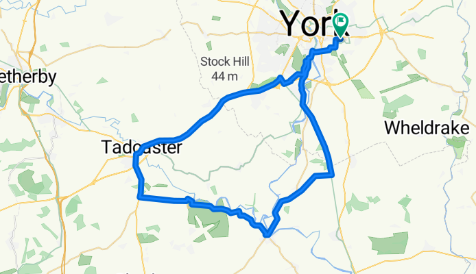
Overview
About this route
- -:--
- Duration
- 50.7 km
- Distance
- 328 m
- Ascent
- 328 m
- Descent
- ---
- Avg. speed
- ---
- Avg. speed

Route quality
Waytypes & surfaces along the route
Waytypes
Cycleway
24.7 km
(49 %)
Busy road
16.1 km
(32 %)
Surfaces
Paved
34.6 km
(68 %)
Unpaved
1 km
(2 %)
Asphalt
34.1 km
(67 %)
Ground
1 km
(2 %)
Continue with Bikemap
Use, edit, or download this cycling route
You would like to ride Siward Street 51 to Siward Street 51 or customize it for your own trip? Here is what you can do with this Bikemap route:
Free features
- Save this route as favorite or in collections
- Copy & plan your own version of this route
- Sync your route with Garmin or Wahoo
Premium features
Free trial for 3 days, or one-time payment. More about Bikemap Premium.
- Navigate this route on iOS & Android
- Export a GPX / KML file of this route
- Create your custom printout (try it for free)
- Download this route for offline navigation
Discover more Premium features.
Get Bikemap PremiumFrom our community
Other popular routes starting in Heslington
 1st FriRide
- Distance
- 38.7 km
- Ascent
- 53 m
- Descent
- 57 m
- Location
- Heslington, England, United Kingdom
 CHE bike club 3
- Distance
- 42.2 km
- Ascent
- 61 m
- Descent
- 59 m
- Location
- Heslington, England, United Kingdom
 Balanced Alcuin Way to Link joining Wigmores North, Sir Theodore's Way, Car storage area
- Distance
- 351.6 km
- Ascent
- 587 m
- Descent
- 514 m
- Location
- Heslington, England, United Kingdom
 Wheldrake Cafe
- Distance
- 49.5 km
- Ascent
- 55 m
- Descent
- 53 m
- Location
- Heslington, England, United Kingdom
 York Tang Hall Library - Huby Circular
- Distance
- 32.4 km
- Ascent
- 25 m
- Descent
- 23 m
- Location
- Heslington, England, United Kingdom
 Kirkham Abbey Lunch
- Distance
- 82.7 km
- Ascent
- 507 m
- Descent
- 507 m
- Location
- Heslington, England, United Kingdom
 Fastest Alcuin Way to Link joining Wigmores North, Sir Theodore's Way, Car storage area
- Distance
- 280.6 km
- Ascent
- 346 m
- Descent
- 273 m
- Location
- Heslington, England, United Kingdom
 York - Howsham Mill - York
- Distance
- 40.6 km
- Ascent
- 134 m
- Descent
- 140 m
- Location
- Heslington, England, United Kingdom
Open it in the app