

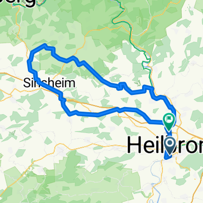
HN Stadtwaldrunde
A cycling route starting in Heilbronn, Baden-Wurttemberg, Germany.
Overview
About this route
This tour is part of an MTB tour concept in the Heilbronn district and urban district and includes an attractive portion of singletrails. This and all other IVB MTB tours were approved and marked in consensus at the 'Round Table' of the Responsible Biking Initiative (IVB), in close cooperation with the Heilbronn district office, the city of Heilbronn, and the forestry department. At this point, special thanks also go to the volunteers who made this project possible with great commitment and passion. Trail sponsor: DAV Section Heilbronn, Mountainbike Department Contact: Joachim Thonig, joachim.thonig@dav-heilbronn.de
- -:--
- Duration
- 26.8 km
- Distance
- 485 m
- Ascent
- 484 m
- Descent
- ---
- Avg. speed
- ---
- Max. altitude

Continue with Bikemap
Use, edit, or download this cycling route
You would like to ride HN Stadtwaldrunde or customize it for your own trip? Here is what you can do with this Bikemap route:
Free features
- Save this route as favorite or in collections
- Copy & plan your own version of this route
- Sync your route with Garmin or Wahoo
Premium features
Free trial for 3 days, or one-time payment. More about Bikemap Premium.
- Navigate this route on iOS & Android
- Export a GPX / KML file of this route
- Create your custom printout (try it for free)
- Download this route for offline navigation
Discover more Premium features.
Get Bikemap PremiumFrom our community
Other popular routes starting in Heilbronn
 Heilbronn - Löwenstein (fast) - Schweinsbergturm - Heilbronn
- Distance
- 38.4 km
- Ascent
- 690 m
- Descent
- 562 m
- Location
- Heilbronn, Baden-Wurttemberg, Germany
 Lange RSG Radrunde von HN nach Sinsheim und Löwenstein und zurück
- Distance
- 101.9 km
- Ascent
- 553 m
- Descent
- 515 m
- Location
- Heilbronn, Baden-Wurttemberg, Germany
 RSG MTB Runde
- Distance
- 40.2 km
- Ascent
- 215 m
- Descent
- 215 m
- Location
- Heilbronn, Baden-Wurttemberg, Germany
 Tour de Hohenlohe - Feierabendtraining
- Distance
- 38.9 km
- Ascent
- 381 m
- Descent
- 343 m
- Location
- Heilbronn, Baden-Wurttemberg, Germany
 Neipperger Runde
- Distance
- 36.4 km
- Ascent
- 355 m
- Descent
- 354 m
- Location
- Heilbronn, Baden-Wurttemberg, Germany
 Kocher-Jagst-Tour Teil 1
- Distance
- 99.3 km
- Ascent
- 826 m
- Descent
- 724 m
- Location
- Heilbronn, Baden-Wurttemberg, Germany
 HN Stadtwaldrunde
- Distance
- 26.8 km
- Ascent
- 485 m
- Descent
- 484 m
- Location
- Heilbronn, Baden-Wurttemberg, Germany
 Neckarbisch 2 100km Sinsheim
- Distance
- 96.1 km
- Ascent
- 1,007 m
- Descent
- 1,025 m
- Location
- Heilbronn, Baden-Wurttemberg, Germany
Open it in the app