

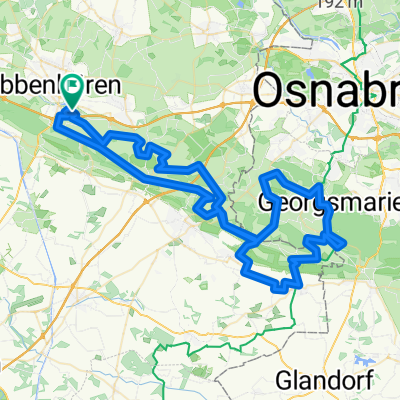
Groner Allee 54, Ibbenbüren nach Lange Straße 47, Osnabrück
A cycling route starting in Ibbenbueren, North Rhine-Westphalia, Germany.
Overview
About this route
- 1 h 47 min
- Duration
- 30.8 km
- Distance
- 277 m
- Ascent
- 276 m
- Descent
- 17.3 km/h
- Avg. speed
- ---
- Avg. speed
Route quality
Waytypes & surfaces along the route
Waytypes
Quiet road
10.2 km
(33 %)
Cycleway
5.4 km
(18 %)
Surfaces
Paved
24.8 km
(80 %)
Unpaved
3.5 km
(11 %)
Asphalt
23 km
(75 %)
Loose gravel
2.3 km
(7 %)
Continue with Bikemap
Use, edit, or download this cycling route
You would like to ride Groner Allee 54, Ibbenbüren nach Lange Straße 47, Osnabrück or customize it for your own trip? Here is what you can do with this Bikemap route:
Free features
- Save this route as favorite or in collections
- Copy & plan your own version of this route
- Sync your route with Garmin or Wahoo
Premium features
Free trial for 3 days, or one-time payment. More about Bikemap Premium.
- Navigate this route on iOS & Android
- Export a GPX / KML file of this route
- Create your custom printout (try it for free)
- Download this route for offline navigation
Discover more Premium features.
Get Bikemap PremiumFrom our community
Other popular routes starting in Ibbenbueren
 Von Ibbenbüren bis Spelle
- Distance
- 23.5 km
- Ascent
- 30 m
- Descent
- 68 m
- Location
- Ibbenbueren, North Rhine-Westphalia, Germany
 Tour nördl. Ibbenbüren
- Distance
- 50.5 km
- Ascent
- 156 m
- Descent
- 169 m
- Location
- Ibbenbueren, North Rhine-Westphalia, Germany
 Teutorundfahrt
- Distance
- 36.5 km
- Ascent
- 135 m
- Descent
- 138 m
- Location
- Ibbenbueren, North Rhine-Westphalia, Germany
 Dickenberg- Recke-Hopsten-Ostenwalde
- Distance
- 35 km
- Ascent
- 115 m
- Descent
- 115 m
- Location
- Ibbenbueren, North Rhine-Westphalia, Germany
 Lagg-FMO-Lagg
- Distance
- 59.5 km
- Ascent
- 227 m
- Descent
- 228 m
- Location
- Ibbenbueren, North Rhine-Westphalia, Germany
 Ibbenbüren - Wersen
- Distance
- 39.8 km
- Ascent
- 210 m
- Descent
- 210 m
- Location
- Ibbenbueren, North Rhine-Westphalia, Germany
 Teutoburgerwaldtocht 85km
- Distance
- 86.5 km
- Ascent
- 960 m
- Descent
- 922 m
- Location
- Ibbenbueren, North Rhine-Westphalia, Germany
 Von Ibbenbüren bis Alfhausen
- Distance
- 35.1 km
- Ascent
- 155 m
- Descent
- 191 m
- Location
- Ibbenbueren, North Rhine-Westphalia, Germany
Open it in the app