

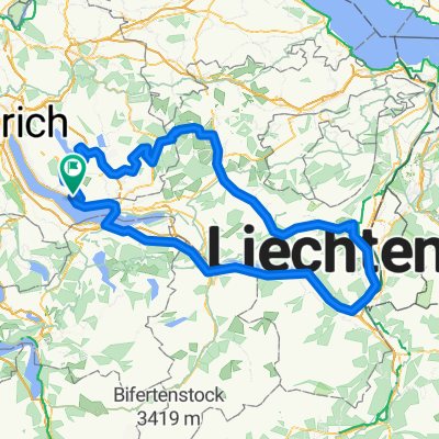
Ricken-Sternenberg
A cycling route starting in Männedorf / Ausserfeld, Canton of Zurich, Switzerland.
Overview
About this route
- -:--
- Duration
- 155 km
- Distance
- 1,573 m
- Ascent
- 1,573 m
- Descent
- ---
- Avg. speed
- ---
- Avg. speed
Route quality
Waytypes & surfaces along the route
Waytypes
Road
61.3 km
(40 %)
Quiet road
42.4 km
(27 %)
Surfaces
Paved
121.4 km
(78 %)
Unpaved
5.3 km
(3 %)
Asphalt
119.8 km
(77 %)
Gravel
3.6 km
(2 %)
Continue with Bikemap
Use, edit, or download this cycling route
You would like to ride Ricken-Sternenberg or customize it for your own trip? Here is what you can do with this Bikemap route:
Free features
- Save this route as favorite or in collections
- Copy & plan your own version of this route
- Sync your route with Garmin or Wahoo
Premium features
Free trial for 3 days, or one-time payment. More about Bikemap Premium.
- Navigate this route on iOS & Android
- Export a GPX / KML file of this route
- Create your custom printout (try it for free)
- Download this route for offline navigation
Discover more Premium features.
Get Bikemap PremiumFrom our community
Other popular routes starting in Männedorf / Ausserfeld
 Gamser-Runde
- Distance
- 207.9 km
- Ascent
- 2,766 m
- Descent
- 2,535 m
- Location
- Männedorf / Ausserfeld, Canton of Zurich, Switzerland
 MTB Pfannenstiel
- Distance
- 34.3 km
- Ascent
- 736 m
- Descent
- 553 m
- Location
- Männedorf / Ausserfeld, Canton of Zurich, Switzerland
 MTB Pfannenstiel CLONED FROM ROUTE 65939
- Distance
- 34.3 km
- Ascent
- 602 m
- Descent
- 602 m
- Location
- Männedorf / Ausserfeld, Canton of Zurich, Switzerland
 Atzmännigrunde
- Distance
- 146.9 km
- Ascent
- 1,835 m
- Descent
- 1,835 m
- Location
- Männedorf / Ausserfeld, Canton of Zurich, Switzerland
 Seestrasse 339D, Männedorf nach Bergstrasse, Stäfa
- Distance
- 8.5 km
- Ascent
- 193 m
- Descent
- 3 m
- Location
- Männedorf / Ausserfeld, Canton of Zurich, Switzerland
 Wiesengrundstrasse 1, Stäfa nach Paradeplatz 11, Zürich
- Distance
- 21.8 km
- Ascent
- 156 m
- Descent
- 153 m
- Location
- Männedorf / Ausserfeld, Canton of Zurich, Switzerland
 Allenbergstrasse 84–84A, Männedorf nach Rathausstrasse 17, Rapperswil-Jona
- Distance
- 12 km
- Ascent
- 87 m
- Descent
- 161 m
- Location
- Männedorf / Ausserfeld, Canton of Zurich, Switzerland
 Alte Sankt Urbanstrasse
- Distance
- 97.6 km
- Ascent
- 835 m
- Descent
- 802 m
- Location
- Männedorf / Ausserfeld, Canton of Zurich, Switzerland
Open it in the app