

Vercors
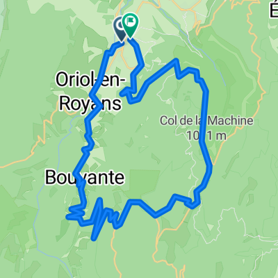
A cycling route starting in Saint-Jean-en-Royans, Auvergne-Rhône-Alpes, France.
Overview
About this route
Depuis Vassieux-en-Vercors: Route de La Come Laval
Vallée de la Choranche
A Rencurel: Route des Ecouges jusqu'a St-Gervais
- -:--
- Duration
- 71.5 km
- Distance
- 1,383 m
- Ascent
- 2,183 m
- Descent
- ---
- Avg. speed
- ---
- Avg. speed
Route quality
Waytypes & surfaces along the route
Waytypes
Busy road
44 km
(62 %)
Road
16.5 km
(23 %)
Surfaces
Paved
57 km
(80 %)
Unpaved
0.5 km
(<1 %)
Asphalt
56.9 km
(80 %)
Ground
0.5 km
(<1 %)
Continue with Bikemap
Use, edit, or download this cycling route
You would like to ride Vercors or customize it for your own trip? Here is what you can do with this Bikemap route:
Free features
- Save this route as favorite or in collections
- Copy & plan your own version of this route
- Sync your route with Garmin or Wahoo
Premium features
Free trial for 3 days, or one-time payment. More about Bikemap Premium.
- Navigate this route on iOS & Android
- Export a GPX / KML file of this route
- Create your custom printout (try it for free)
- Download this route for offline navigation
Discover more Premium features.
Get Bikemap PremiumFrom our community
Other popular routes starting in Saint-Jean-en-Royans
 Saint-Jean-en-Royans - Col de la Machine 64km-1680m
- Distance
- 64.2 km
- Ascent
- 1,581 m
- Descent
- 1,579 m
- Location
- Saint-Jean-en-Royans, Auvergne-Rhône-Alpes, France
 Avenue du Sert 2, Saint-Jean-en-Royans nach Avenue du Sert 2, Saint-Jean-en-Royans
- Distance
- 77.4 km
- Ascent
- 2,019 m
- Descent
- 2,018 m
- Location
- Saint-Jean-en-Royans, Auvergne-Rhône-Alpes, France
 testers bliss
- Distance
- 27.6 km
- Ascent
- 294 m
- Descent
- 294 m
- Location
- Saint-Jean-en-Royans, Auvergne-Rhône-Alpes, France
 Vercors 4
- Distance
- 120.8 km
- Ascent
- 2,221 m
- Descent
- 2,221 m
- Location
- Saint-Jean-en-Royans, Auvergne-Rhône-Alpes, France
 Col de Rousset Plus 10 More Vercors Cols from Bataille
- Distance
- 128.2 km
- Ascent
- 2,159 m
- Descent
- 2,169 m
- Location
- Saint-Jean-en-Royans, Auvergne-Rhône-Alpes, France
 Combe Laval, Col de la Bataille Loop
- Distance
- 64.3 km
- Ascent
- 1,507 m
- Descent
- 1,512 m
- Location
- Saint-Jean-en-Royans, Auvergne-Rhône-Alpes, France
 Combe Lavel Rundtour 50km
- Distance
- 37.8 km
- Ascent
- 1,821 m
- Descent
- 1,807 m
- Location
- Saint-Jean-en-Royans, Auvergne-Rhône-Alpes, France
 Combe Lavel Rundtour 50km
- Distance
- 37.8 km
- Ascent
- 1,821 m
- Descent
- 1,807 m
- Location
- Saint-Jean-en-Royans, Auvergne-Rhône-Alpes, France
Open it in the app