
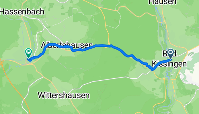
kg-oberthulba
A cycling route starting in Bad Kissingen, Bavaria, Germany.
Overview
About this route
- 37 min
- Duration
- 9.8 km
- Distance
- 140 m
- Ascent
- 70 m
- Descent
- 15.7 km/h
- Avg. speed
- ---
- Avg. speed

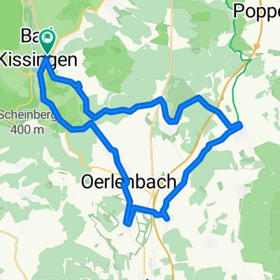
Route quality
Waytypes & surfaces along the route
Waytypes
Quiet road
4 km
(41 %)
Path
2.4 km
(24 %)
Surfaces
Paved
9.7 km
(99 %)
Asphalt
9.7 km
(99 %)
Undefined
0.1 km
(<1 %)
Continue with Bikemap
Use, edit, or download this cycling route
You would like to ride kg-oberthulba or customize it for your own trip? Here is what you can do with this Bikemap route:
Free features
- Save this route as favorite or in collections
- Copy & plan your own version of this route
- Sync your route with Garmin or Wahoo
Premium features
Free trial for 3 days, or one-time payment. More about Bikemap Premium.
- Navigate this route on iOS & Android
- Export a GPX / KML file of this route
- Create your custom printout (try it for free)
- Download this route for offline navigation
Discover more Premium features.
Get Bikemap PremiumFrom our community
Other popular routes starting in Bad Kissingen
 Freitag
- Distance
- 33.4 km
- Ascent
- 366 m
- Descent
- 366 m
- Location
- Bad Kissingen, Bavaria, Germany
 KG 31 km 430 hm
- Distance
- 31.1 km
- Ascent
- 376 m
- Descent
- 379 m
- Location
- Bad Kissingen, Bavaria, Germany
 Radwanderweg Vom Main zur Rhön Etappe 2
- Distance
- 58.5 km
- Ascent
- 325 m
- Descent
- 263 m
- Location
- Bad Kissingen, Bavaria, Germany
 BK-Gradierbau-Saline-Bismarck-Botenlauben-Wittelsbacher Turm-BK
- Distance
- 25.5 km
- Ascent
- 470 m
- Descent
- 469 m
- Location
- Bad Kissingen, Bavaria, Germany
 BK-Basaltsäulen Gangolfsberg-BK
- Distance
- 100.7 km
- Ascent
- 444 m
- Descent
- 496 m
- Location
- Bad Kissingen, Bavaria, Germany
 2012/06/09
- Distance
- 58.6 km
- Ascent
- 602 m
- Descent
- 602 m
- Location
- Bad Kissingen, Bavaria, Germany
 Rundweg Bad Bocklet Nüdlingen
- Distance
- 22.9 km
- Ascent
- 351 m
- Descent
- 343 m
- Location
- Bad Kissingen, Bavaria, Germany
 Hochrhöner 1 Bad Kisssingen 565791.gpx
- Distance
- 9.8 km
- Ascent
- 257 m
- Descent
- 178 m
- Location
- Bad Kissingen, Bavaria, Germany
Open it in the app