
2020-04-25 16:14:20
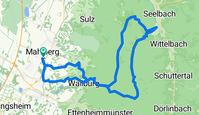
A cycling route starting in Mahlberg, Baden-Württemberg, Germany.
Overview
About this route
geiler Trail vom Langenhard nach Seelbach
- -:--
- Duration
- 35.8 km
- Distance
- 825 m
- Ascent
- 826 m
- Descent
- ---
- Avg. speed
- ---
- Avg. speed

Continue with Bikemap
Use, edit, or download this cycling route
You would like to ride 2020-04-25 16:14:20 or customize it for your own trip? Here is what you can do with this Bikemap route:
Free features
- Save this route as favorite or in collections
- Copy & plan your own version of this route
- Sync your route with Garmin or Wahoo
Premium features
Free trial for 3 days, or one-time payment. More about Bikemap Premium.
- Navigate this route on iOS & Android
- Export a GPX / KML file of this route
- Create your custom printout (try it for free)
- Download this route for offline navigation
Discover more Premium features.
Get Bikemap PremiumFrom our community
Other popular routes starting in Mahlberg
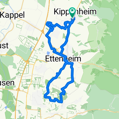 wein
wein- Distance
- 29.2 km
- Ascent
- 297 m
- Descent
- 298 m
- Location
- Mahlberg, Baden-Württemberg, Germany
 Taubergießen
- Distance
- 39 km
- Ascent
- 68 m
- Descent
- 66 m
- Location
- Mahlberg, Baden-Württemberg, Germany
 Mahlberg-Streitberg-StilfzerFritz-4BurgenTrail zurück
- Distance
- 49.4 km
- Ascent
- 462 m
- Descent
- 457 m
- Location
- Mahlberg, Baden-Württemberg, Germany
 Mahlberg-Riegel-Sasbach am Kaiserstuhl-Weisweil-Mahlberg
- Distance
- 75.5 km
- Ascent
- 68 m
- Descent
- 69 m
- Location
- Mahlberg, Baden-Württemberg, Germany
 Mahlberg / Geroldeck und zurück
- Distance
- 45.6 km
- Ascent
- 709 m
- Descent
- 709 m
- Location
- Mahlberg, Baden-Württemberg, Germany
 Feierabendrunde mit coolen Uphill-Trails
- Distance
- 37.7 km
- Ascent
- 877 m
- Descent
- 876 m
- Location
- Mahlberg, Baden-Württemberg, Germany
 Windräder/Hasenberg/Langenhard/Reichenbach über Langenhard zurück
- Distance
- 37.9 km
- Ascent
- 732 m
- Descent
- 708 m
- Location
- Mahlberg, Baden-Württemberg, Germany
 2020-04-25 16:14:20
- Distance
- 35.8 km
- Ascent
- 825 m
- Descent
- 826 m
- Location
- Mahlberg, Baden-Württemberg, Germany
Open it in the app