

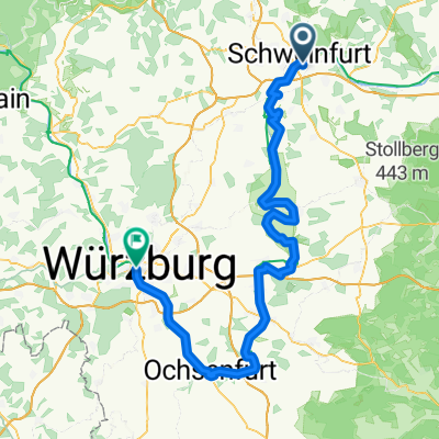
Volkach/Werneck
A cycling route starting in Sennfeld, Bavaria, Germany.
Overview
About this route
- 3 h 41 min
- Duration
- 63.6 km
- Distance
- 50 m
- Ascent
- 50 m
- Descent
- 17.3 km/h
- Avg. speed
- ---
- Avg. speed

Route quality
Waytypes & surfaces along the route
Waytypes
Path
22.3 km
(35 %)
Road
16.7 km
(26 %)
Surfaces
Paved
52.8 km
(83 %)
Unpaved
0.7 km
(1 %)
Asphalt
48.7 km
(77 %)
Paved (undefined)
3.3 km
(5 %)
Continue with Bikemap
Use, edit, or download this cycling route
You would like to ride Volkach/Werneck or customize it for your own trip? Here is what you can do with this Bikemap route:
Free features
- Save this route as favorite or in collections
- Copy & plan your own version of this route
- Sync your route with Garmin or Wahoo
Premium features
Free trial for 3 days, or one-time payment. More about Bikemap Premium.
- Navigate this route on iOS & Android
- Export a GPX / KML file of this route
- Create your custom printout (try it for free)
- Download this route for offline navigation
Discover more Premium features.
Get Bikemap PremiumFrom our community
Other popular routes starting in Sennfeld
 Pfingstsonntag Tripp 2020
- Distance
- 66 km
- Ascent
- 397 m
- Descent
- 398 m
- Location
- Sennfeld, Bavaria, Germany
 sw 1
sw 1- Distance
- 7.3 km
- Ascent
- 132 m
- Descent
- 62 m
- Location
- Sennfeld, Bavaria, Germany
 Lange Ausfahrt von Schweinfurt nach Würzburg
- Distance
- 102.1 km
- Ascent
- 78 m
- Descent
- 112 m
- Location
- Sennfeld, Bavaria, Germany
 Baggersee/Werneck/Schnackenwerth
- Distance
- 32.3 km
- Ascent
- 50 m
- Descent
- 50 m
- Location
- Sennfeld, Bavaria, Germany
 Maxbrücke/Bergrh/Türme und zurück
- Distance
- 22.9 km
- Ascent
- 20 m
- Descent
- 20 m
- Location
- Sennfeld, Bavaria, Germany
 Schweinfurt-Altmannsdorf
- Distance
- 47.6 km
- Ascent
- 177 m
- Descent
- 165 m
- Location
- Sennfeld, Bavaria, Germany
 Schweinfurt-Werntal-Gemünden-Saaletal-Euerdorf
- Distance
- 106.1 km
- Ascent
- 573 m
- Descent
- 637 m
- Location
- Sennfeld, Bavaria, Germany
 Sennfeld - Dettelbach
- Distance
- 58.6 km
- Ascent
- 131 m
- Descent
- 150 m
- Location
- Sennfeld, Bavaria, Germany
Open it in the app