

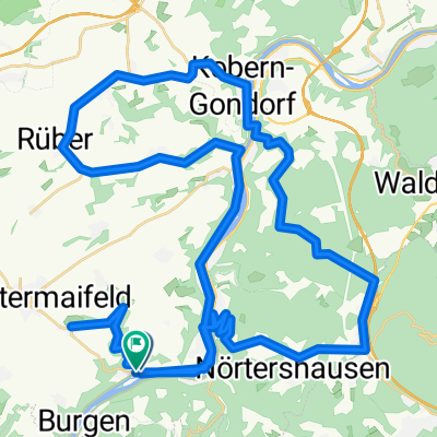
Maifeld-Mosel-Runde
A cycling route starting in Hatzenport, Rhineland-Palatinate, Germany.
Overview
About this route
Abwechslungsreiche Runde beginnend im Schrumpftal, runter an die Mosel nach Hatzenport. Von dort auf Radweg parallel zur B416 bis Kobern. Landstraße über Dreckenach nach Rüber. Nach einem kurzen Anstieg bis Kaan nach Polch. Dort auf den Maifeldradweg (ehemalige Bahntrasse) bis Münstermaifeld.
- -:--
- Duration
- 39.8 km
- Distance
- 488 m
- Ascent
- 482 m
- Descent
- ---
- Avg. speed
- 236 m
- Avg. speed
Route quality
Waytypes & surfaces along the route
Waytypes
Busy road
14 km
(35 %)
Path
8.3 km
(21 %)
Surfaces
Paved
27.7 km
(70 %)
Unpaved
1.6 km
(4 %)
Asphalt
26.6 km
(67 %)
Ground
1.5 km
(4 %)
Continue with Bikemap
Use, edit, or download this cycling route
You would like to ride Maifeld-Mosel-Runde or customize it for your own trip? Here is what you can do with this Bikemap route:
Free features
- Save this route as favorite or in collections
- Copy & plan your own version of this route
- Sync your route with Garmin or Wahoo
Premium features
Free trial for 3 days, or one-time payment. More about Bikemap Premium.
- Navigate this route on iOS & Android
- Export a GPX / KML file of this route
- Create your custom printout (try it for free)
- Download this route for offline navigation
Discover more Premium features.
Get Bikemap PremiumFrom our community
Other popular routes starting in Hatzenport
 moezel richting noordwest ingekort tot 53 km
- Distance
- 53.1 km
- Ascent
- 678 m
- Descent
- 687 m
- Location
- Hatzenport, Rhineland-Palatinate, Germany
 moseltour mit ein paar steigung und canyon strecke2
- Distance
- 60.2 km
- Ascent
- 756 m
- Descent
- 755 m
- Location
- Hatzenport, Rhineland-Palatinate, Germany
 moezel 78 km zuidoost bijna helemaal langs fietsroutes schinderhannes en hundsruck-mosel
- Distance
- 78.9 km
- Ascent
- 694 m
- Descent
- 685 m
- Location
- Hatzenport, Rhineland-Palatinate, Germany
 Hatzenport Küppchen und zurück
- Distance
- 17.1 km
- Ascent
- 246 m
- Descent
- 246 m
- Location
- Hatzenport, Rhineland-Palatinate, Germany
 Maifeld-Mosel-Rundtour 010509
- Distance
- 29.2 km
- Ascent
- 340 m
- Descent
- 401 m
- Location
- Hatzenport, Rhineland-Palatinate, Germany
 Traumpfad Hatzenporter Laysteig
- Distance
- 11.9 km
- Ascent
- 408 m
- Descent
- 407 m
- Location
- Hatzenport, Rhineland-Palatinate, Germany
 Hatzenport_Koblenz.gpx
- Distance
- 31.5 km
- Ascent
- 163 m
- Descent
- 166 m
- Location
- Hatzenport, Rhineland-Palatinate, Germany
 Mosel-Maifeld Radroute 32km
- Distance
- 31.7 km
- Ascent
- 469 m
- Descent
- 469 m
- Location
- Hatzenport, Rhineland-Palatinate, Germany
Open it in the app