

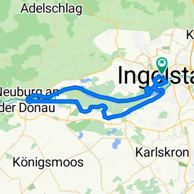
Rundkurs Ingolstadt-Weichering-Irgertsheim-Gerolfing-IN
A cycling route starting in Ingolstadt, Bavaria, Germany.
Overview
About this route
Schöner, flacher Rundweg, größtenteils im Schatten von Bäumen, auch mit Kindern möglich zu fahren. Start und Ziel hier Ingolstadt Mitte, jeder andere Startpunkt möglich. Rast in Weichering (gute, preiswerte Küche) Weiter am Schloß Grünau (ND) vorbei, über die Donau und an der Nordseite der Donau zurück über Gerolfing.
- -:--
- Duration
- 34.1 km
- Distance
- 57 m
- Ascent
- 61 m
- Descent
- ---
- Avg. speed
- 387 m
- Avg. speed

Route quality
Waytypes & surfaces along the route
Waytypes
Track
19 km
(56 %)
Quiet road
9.1 km
(27 %)
Surfaces
Paved
18.2 km
(53 %)
Unpaved
13.2 km
(39 %)
Asphalt
14.6 km
(43 %)
Gravel
9.8 km
(29 %)
Route highlights
Points of interest along the route
Accommodation after 9.7 km
Landgasthof Vogelsang www.landgasthof-vogelsang.de
Continue with Bikemap
Use, edit, or download this cycling route
You would like to ride Rundkurs Ingolstadt-Weichering-Irgertsheim-Gerolfing-IN or customize it for your own trip? Here is what you can do with this Bikemap route:
Free features
- Save this route as favorite or in collections
- Copy & plan your own version of this route
- Sync your route with Garmin or Wahoo
Premium features
Free trial for 3 days, or one-time payment. More about Bikemap Premium.
- Navigate this route on iOS & Android
- Export a GPX / KML file of this route
- Create your custom printout (try it for free)
- Download this route for offline navigation
Discover more Premium features.
Get Bikemap PremiumFrom our community
Other popular routes starting in Ingolstadt
 ingolstadt - münchen
- Distance
- 94.8 km
- Ascent
- 415 m
- Descent
- 294 m
- Location
- Ingolstadt, Bavaria, Germany
 Neuburgtour 8/2010
- Distance
- 47.7 km
- Ascent
- 61 m
- Descent
- 61 m
- Location
- Ingolstadt, Bavaria, Germany
 Altmühltalrunde
- Distance
- 90.5 km
- Ascent
- 404 m
- Descent
- 402 m
- Location
- Ingolstadt, Bavaria, Germany
 Baggersee - Wildgehege
- Distance
- 9.9 km
- Ascent
- 26 m
- Descent
- 22 m
- Location
- Ingolstadt, Bavaria, Germany
 Schmetterlingsweg im Altmühltal
- Distance
- 120 km
- Ascent
- 1,048 m
- Descent
- 1,000 m
- Location
- Ingolstadt, Bavaria, Germany
 OstRunde - Geisenfeld- Führholzen -Adelsberg
- Distance
- 49.5 km
- Ascent
- 110 m
- Descent
- 112 m
- Location
- Ingolstadt, Bavaria, Germany
 Tour de Houblon 2013
- Distance
- 94.5 km
- Ascent
- 275 m
- Descent
- 274 m
- Location
- Ingolstadt, Bavaria, Germany
 Ingolstadt-Wien along the Danube
- Distance
- 548.4 km
- Ascent
- 186 m
- Descent
- 385 m
- Location
- Ingolstadt, Bavaria, Germany
Open it in the app