
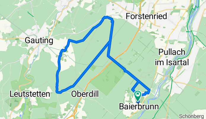
Leichte Runde durch den Forstenrieder Park
A cycling route starting in Baierbrunn, Bavaria, Germany.
Overview
About this route
Vom Parkplatz an der kath. Kirche in Baierbrunn geht es auf teils asphaltierten, teils geschotterten Wegen durch den Forstenrieder Park. Die Runde führt über Buchendorf und Neuried wieder zum Ausganspunkt zurück. Einkehrmöglichkeit in Buchendorf und mit kl. abstecher in Neuried. Im Forstenrieder Park Gelegenheit zur Wildbeobachtung.
- -:--
- Duration
- 30.8 km
- Distance
- 181 m
- Ascent
- 215 m
- Descent
- ---
- Avg. speed
- 646 m
- Avg. speed
Route quality
Waytypes & surfaces along the route
Waytypes
Track
24.7 km
(80 %)
Quiet road
5.3 km
(17 %)
Surfaces
Paved
22.7 km
(74 %)
Unpaved
8.1 km
(26 %)
Asphalt
22.6 km
(73 %)
Gravel
5.8 km
(19 %)
Continue with Bikemap
Use, edit, or download this cycling route
You would like to ride Leichte Runde durch den Forstenrieder Park or customize it for your own trip? Here is what you can do with this Bikemap route:
Free features
- Save this route as favorite or in collections
- Copy & plan your own version of this route
- Sync your route with Garmin or Wahoo
Premium features
Free trial for 3 days, or one-time payment. More about Bikemap Premium.
- Navigate this route on iOS & Android
- Export a GPX / KML file of this route
- Create your custom printout (try it for free)
- Download this route for offline navigation
Discover more Premium features.
Get Bikemap PremiumFrom our community
Other popular routes starting in Baierbrunn
 München-Forst Kasten-Baierbrunn-Großhesselohe
- Distance
- 31.1 km
- Ascent
- 271 m
- Descent
- 273 m
- Location
- Baierbrunn, Bavaria, Germany
 Große Starnberger See Runde
- Distance
- 89.2 km
- Ascent
- 378 m
- Descent
- 380 m
- Location
- Baierbrunn, Bavaria, Germany
 Wegzurücksuchen am Ammersee
- Distance
- 108 km
- Ascent
- 441 m
- Descent
- 441 m
- Location
- Baierbrunn, Bavaria, Germany
 Kochelsse Juni 2012
- Distance
- 68.7 km
- Ascent
- 459 m
- Descent
- 464 m
- Location
- Baierbrunn, Bavaria, Germany
 Sunday.05.07
- Distance
- 46.4 km
- Ascent
- 232 m
- Descent
- 291 m
- Location
- Baierbrunn, Bavaria, Germany
 Hash plan today
- Distance
- 9.3 km
- Ascent
- 143 m
- Descent
- 142 m
- Location
- Baierbrunn, Bavaria, Germany
 Krailling - Buchenhain
- Distance
- 13.5 km
- Ascent
- 12 m
- Descent
- 94 m
- Location
- Baierbrunn, Bavaria, Germany
 sonntagstour_NGS
- Distance
- 28.2 km
- Ascent
- 195 m
- Descent
- 155 m
- Location
- Baierbrunn, Bavaria, Germany
Open it in the app