

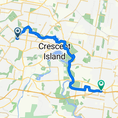
Canley Height to Revesby
A cycling route starting in Cabramatta West, New South Wales, Australia.
Overview
About this route
- 1 h 32 min
- Duration
- 21 km
- Distance
- 3 m
- Ascent
- 28 m
- Descent
- 13.7 km/h
- Avg. speed
- ---
- Avg. speed
Route quality
Waytypes & surfaces along the route
Waytypes
Cycleway
14.9 km
(71 %)
Quiet road
3.3 km
(16 %)
Surfaces
Paved
19 km
(91 %)
Paved (undefined)
10.7 km
(51 %)
Concrete
6.4 km
(30 %)
Continue with Bikemap
Use, edit, or download this cycling route
You would like to ride Canley Height to Revesby or customize it for your own trip? Here is what you can do with this Bikemap route:
Free features
- Save this route as favorite or in collections
- Copy & plan your own version of this route
- Sync your route with Garmin or Wahoo
Premium features
Free trial for 3 days, or one-time payment. More about Bikemap Premium.
- Navigate this route on iOS & Android
- Export a GPX / KML file of this route
- Create your custom printout (try it for free)
- Download this route for offline navigation
Discover more Premium features.
Get Bikemap PremiumFrom our community
Other popular routes starting in Cabramatta West
 23 Stevenage Road, Canley Heights to 23 Stevenage Road, Canley Heights
- Distance
- 15.1 km
- Ascent
- 66 m
- Descent
- 66 m
- Location
- Cabramatta West, New South Wales, Australia
 148–154 Edensor Road, Bonnyrigg to 34 Bird Walton Avenue, Middleton Grange
- Distance
- 9.1 km
- Ascent
- 68 m
- Descent
- 65 m
- Location
- Cabramatta West, New South Wales, Australia
 Canley Height to Revesby
- Distance
- 21 km
- Ascent
- 3 m
- Descent
- 28 m
- Location
- Cabramatta West, New South Wales, Australia
 30k wetherill park ride
- Distance
- 29.1 km
- Ascent
- 219 m
- Descent
- 217 m
- Location
- Cabramatta West, New South Wales, Australia
 Marsden Road 38, Liverpool to Woodlands Road 111B, Liverpool
- Distance
- 1.5 km
- Ascent
- 3 m
- Descent
- 21 m
- Location
- Cabramatta West, New South Wales, Australia
 36 Pritchard Street, Mt Pritchard to 132 Newton Road, Wetherill Park
- Distance
- 8.4 km
- Ascent
- 55 m
- Descent
- 52 m
- Location
- Cabramatta West, New South Wales, Australia
 Mimosa Road 247, Greenfield Park to Troubadour T-Way, Glenwood
- Distance
- 20 km
- Ascent
- 286 m
- Descent
- 269 m
- Location
- Cabramatta West, New South Wales, Australia
 170 Kalang Road, Edensor Park to 14 Zircon Street, Bossley Park
- Distance
- 5.4 km
- Ascent
- 36 m
- Descent
- 36 m
- Location
- Cabramatta West, New South Wales, Australia
Open it in the app