

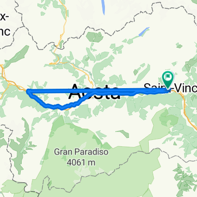
BREUIL-CERVINIA, por Châtillon
A cycling route starting in Châtillon, Aosta Valley, Italy.
Overview
About this route
Subida.
- -:--
- Duration
- 26.4 km
- Distance
- 1,459 m
- Ascent
- 4 m
- Descent
- ---
- Avg. speed
- ---
- Avg. speed
Route quality
Waytypes & surfaces along the route
Waytypes
Busy road
25.5 km
(97 %)
Access road
0.5 km
(2 %)
Quiet road
0.4 km
(2 %)
Surfaces
Paved
16 km
(61 %)
Asphalt
16 km
(61 %)
Undefined
10.4 km
(39 %)
Continue with Bikemap
Use, edit, or download this cycling route
You would like to ride BREUIL-CERVINIA, por Châtillon or customize it for your own trip? Here is what you can do with this Bikemap route:
Free features
- Save this route as favorite or in collections
- Copy & plan your own version of this route
- Sync your route with Garmin or Wahoo
Premium features
Free trial for 3 days, or one-time payment. More about Bikemap Premium.
- Navigate this route on iOS & Android
- Export a GPX / KML file of this route
- Create your custom printout (try it for free)
- Download this route for offline navigation
Discover more Premium features.
Get Bikemap PremiumFrom our community
Other popular routes starting in Châtillon
 Etape Giro 2018
- Distance
- 99.8 km
- Ascent
- 3,480 m
- Descent
- 1,993 m
- Location
- Châtillon, Aosta Valley, Italy
 Chatillon - St Jean des Allemands
- Distance
- 84.9 km
- Ascent
- 1,820 m
- Descent
- 1,857 m
- Location
- Châtillon, Aosta Valley, Italy
 BREUIL-CERVINIA, por Châtillon
- Distance
- 26.4 km
- Ascent
- 1,459 m
- Descent
- 4 m
- Location
- Châtillon, Aosta Valley, Italy
 Cervinia
- Distance
- 27 km
- Ascent
- 1,505 m
- Descent
- 21 m
- Location
- Châtillon, Aosta Valley, Italy
 Frankovska_D_13
- Distance
- 90.7 km
- Ascent
- 339 m
- Descent
- 644 m
- Location
- Châtillon, Aosta Valley, Italy
 Giro di Cervinia
- Distance
- 56.8 km
- Ascent
- 1,747 m
- Descent
- 1,744 m
- Location
- Châtillon, Aosta Valley, Italy
 Chatillon - La Salle
- Distance
- 92.5 km
- Ascent
- 2,772 m
- Descent
- 2,734 m
- Location
- Châtillon, Aosta Valley, Italy
 Chatillon - St Jean des Allemands
- Distance
- 82 km
- Ascent
- 2,058 m
- Descent
- 2,085 m
- Location
- Châtillon, Aosta Valley, Italy
Open it in the app