

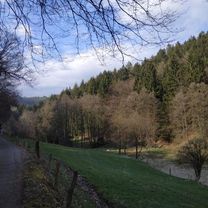
Nachrodt-Wiblingwerde: Rundweg Nachrodt mit Blick auf die Lenne
A cycling route starting in Nachrodt-Wiblingwerde, North Rhine-Westphalia, Germany.
Overview
About this route
Auf dieser Route begeben Sie sich auf geschichtliche Spurensuche! Sie führt in die östlich der Lenne gelegenen Berge und bietet weite Aussichten über Nachrodt und das Lennetal.
- 2 h 21 min
- Duration
- 13.5 km
- Distance
- 587 m
- Ascent
- 586 m
- Descent
- 5.7 km/h
- Avg. speed
- ---
- Avg. speed
Route quality
Waytypes & surfaces along the route
Waytypes
Track
8.7 km
(64 %)
Access road
1.2 km
(9 %)
Surfaces
Paved
2.2 km
(16 %)
Unpaved
9.1 km
(68 %)
Gravel
3.4 km
(25 %)
Unpaved (undefined)
3.1 km
(23 %)
Continue with Bikemap
Use, edit, or download this cycling route
You would like to ride Nachrodt-Wiblingwerde: Rundweg Nachrodt mit Blick auf die Lenne or customize it for your own trip? Here is what you can do with this Bikemap route:
Free features
- Save this route as favorite or in collections
- Copy & plan your own version of this route
- Sync your route with Garmin or Wahoo
Premium features
Free trial for 3 days, or one-time payment. More about Bikemap Premium.
- Navigate this route on iOS & Android
- Export a GPX / KML file of this route
- Create your custom printout (try it for free)
- Download this route for offline navigation
Discover more Premium features.
Get Bikemap PremiumFrom our community
Other popular routes starting in Nachrodt-Wiblingwerde
 Singletrailrunde Letmathe
- Distance
- 16.2 km
- Ascent
- 351 m
- Descent
- 348 m
- Location
- Nachrodt-Wiblingwerde, North Rhine-Westphalia, Germany
 Singletrailrunde Letmathe
- Distance
- 16.2 km
- Ascent
- 393 m
- Descent
- 391 m
- Location
- Nachrodt-Wiblingwerde, North Rhine-Westphalia, Germany
 MTB 1
MTB 1- Distance
- 41 km
- Ascent
- 838 m
- Descent
- 838 m
- Location
- Nachrodt-Wiblingwerde, North Rhine-Westphalia, Germany
 Obernahmerstraße 58, Hagen do Obernahmerstraße 58, Hagen
- Distance
- 13.9 km
- Ascent
- 266 m
- Descent
- 265 m
- Location
- Nachrodt-Wiblingwerde, North Rhine-Westphalia, Germany
 In der Hardt 4, Nachrodt-Wiblingwerde nach In der Hardt 4, Nachrodt-Wiblingwerde
- Distance
- 36.6 km
- Ascent
- 472 m
- Descent
- 468 m
- Location
- Nachrodt-Wiblingwerde, North Rhine-Westphalia, Germany
 Mountainbike Tour Wandertag 2009
- Distance
- 22.2 km
- Ascent
- 482 m
- Descent
- 482 m
- Location
- Nachrodt-Wiblingwerde, North Rhine-Westphalia, Germany
 Rund ums Schloß Hohenlimburg
- Distance
- 48.2 km
- Ascent
- 778 m
- Descent
- 778 m
- Location
- Nachrodt-Wiblingwerde, North Rhine-Westphalia, Germany
 Tour ins Sauerland
- Distance
- 108.3 km
- Ascent
- 1,751 m
- Descent
- 1,836 m
- Location
- Nachrodt-Wiblingwerde, North Rhine-Westphalia, Germany
Open it in the app