
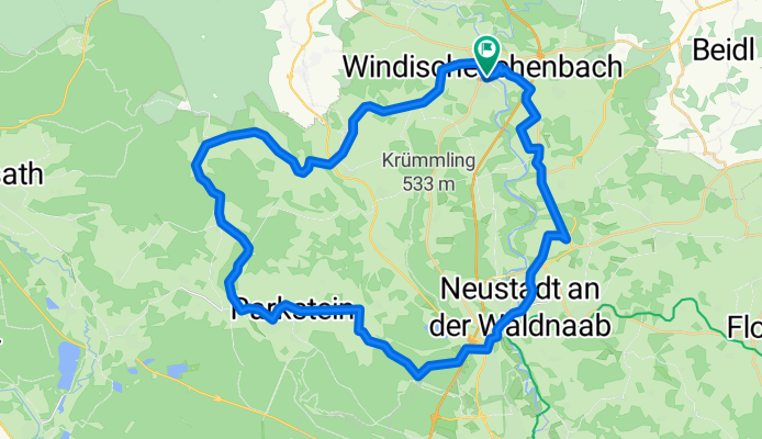
Waldnaabtal-Tour
A cycling route starting in Windischeschenbach, Bavaria, Germany.
Overview
About this route
Diese GPS-Daten sind Eigentum des Projektes geo-coaching und ausschliesslich zur privaten Verwendung besimmt. Eine kommerzielle Verwendung ist ohne Genehmigung nicht gestattet.
- 2 h 49 min
- Duration
- 42.4 km
- Distance
- 676 m
- Ascent
- 673 m
- Descent
- 15 km/h
- Avg. speed
- ---
- Avg. speed
Route quality
Waytypes & surfaces along the route
Waytypes
Quiet road
18 km
(42 %)
Road
15.7 km
(37 %)
Surfaces
Paved
38.5 km
(91 %)
Unpaved
3.3 km
(8 %)
Asphalt
37.4 km
(88 %)
Gravel
3.3 km
(8 %)
Continue with Bikemap
Use, edit, or download this cycling route
You would like to ride Waldnaabtal-Tour or customize it for your own trip? Here is what you can do with this Bikemap route:
Free features
- Save this route as favorite or in collections
- Copy & plan your own version of this route
- Sync your route with Garmin or Wahoo
Premium features
Free trial for 3 days, or one-time payment. More about Bikemap Premium.
- Navigate this route on iOS & Android
- Export a GPX / KML file of this route
- Create your custom printout (try it for free)
- Download this route for offline navigation
Discover more Premium features.
Get Bikemap PremiumFrom our community
Other popular routes starting in Windischeschenbach
 Entwurf A Strecke Pano 2015
- Distance
- 234 km
- Ascent
- 1,594 m
- Descent
- 1,594 m
- Location
- Windischeschenbach, Bavaria, Germany
 D 2013
- Distance
- 74.7 km
- Ascent
- 767 m
- Descent
- 770 m
- Location
- Windischeschenbach, Bavaria, Germany
 win-silb-alte-win
- Distance
- 73.1 km
- Ascent
- 775 m
- Descent
- 778 m
- Location
- Windischeschenbach, Bavaria, Germany
 B 2015 Entwurf neu
- Distance
- 168.6 km
- Ascent
- 1,334 m
- Descent
- 1,335 m
- Location
- Windischeschenbach, Bavaria, Germany
 B- Strecke PT 2011
- Distance
- 181.9 km
- Ascent
- 1,620 m
- Descent
- 1,620 m
- Location
- Windischeschenbach, Bavaria, Germany
 Německo 2012_Waldnaabtal-Ohře-D1-18.9.Út
- Distance
- 34.5 km
- Ascent
- 366 m
- Descent
- 240 m
- Location
- Windischeschenbach, Bavaria, Germany
 Scherreuth Abzw., Windischeschenbach nach Pfeifferstraße 2, Weiden in der Oberpfalz
- Distance
- 14.4 km
- Ascent
- 70 m
- Descent
- 230 m
- Location
- Windischeschenbach, Bavaria, Germany
 C 2014
- Distance
- 102.6 km
- Ascent
- 1,094 m
- Descent
- 1,094 m
- Location
- Windischeschenbach, Bavaria, Germany
Open it in the app