
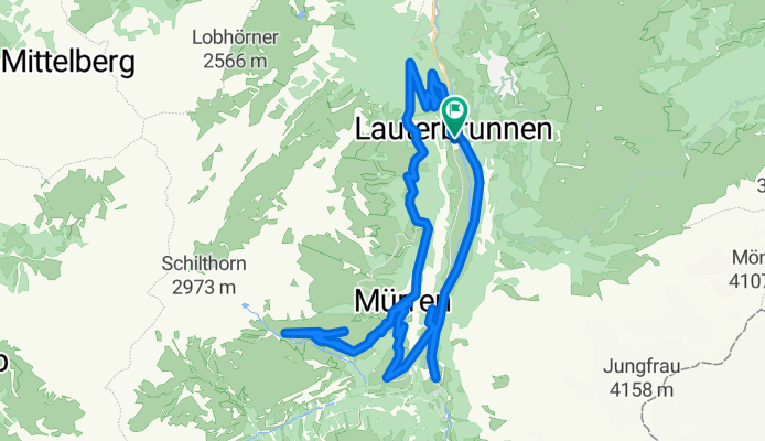
Above Murren to Shiltalp
A cycling route starting in Lauterbrunnen, Canton of Bern, Switzerland.
Overview
About this route
- -:--
- Duration
- 32.5 km
- Distance
- 1,329 m
- Ascent
- 1,329 m
- Descent
- ---
- Avg. speed
- ---
- Avg. speed

Route highlights
Points of interest along the route
Point of interest after 10.2 km
Murren
Point of interest after 15.3 km
Shiltalp
Point of interest after 24.4 km
Cable Car down from Gimmelwald
Continue with Bikemap
Use, edit, or download this cycling route
You would like to ride Above Murren to Shiltalp or customize it for your own trip? Here is what you can do with this Bikemap route:
Free features
- Save this route as favorite or in collections
- Copy & plan your own version of this route
- Sync your route with Garmin or Wahoo
Premium features
Free trial for 3 days, or one-time payment. More about Bikemap Premium.
- Navigate this route on iOS & Android
- Export a GPX / KML file of this route
- Create your custom printout (try it for free)
- Download this route for offline navigation
Discover more Premium features.
Get Bikemap PremiumFrom our community
Other popular routes starting in Lauterbrunnen
 Bahnhofstrasse 121F, Gündlischwand nach Im Stechelberg 483B, Lauterbrunnen
- Distance
- 12.4 km
- Ascent
- 317 m
- Descent
- 59 m
- Location
- Lauterbrunnen, Canton of Bern, Switzerland
 murren grosse Schidegg
- Distance
- 35.9 km
- Ascent
- 1,912 m
- Descent
- 1,662 m
- Location
- Lauterbrunnen, Canton of Bern, Switzerland
 Zweilütschinen - Grindelwald - kleine Scheidegg - Berghaus Grindelwaldblick - Wengen - Zweilütschinen
- Distance
- 38.9 km
- Ascent
- 1,555 m
- Descent
- 1,554 m
- Location
- Lauterbrunnen, Canton of Bern, Switzerland
 Ägerten 1079C, Mürren to Lengwald 301, Stechelberg
- Distance
- 57.2 km
- Ascent
- 3,008 m
- Descent
- 3,617 m
- Location
- Lauterbrunnen, Canton of Bern, Switzerland
 Lauterbrunnen - Murren - Shiltalp
- Distance
- 36.7 km
- Ascent
- 2,312 m
- Descent
- 2,323 m
- Location
- Lauterbrunnen, Canton of Bern, Switzerland
 Klein and Gross Scheidegg
- Distance
- 68 km
- Ascent
- 2,170 m
- Descent
- 2,651 m
- Location
- Lauterbrunnen, Canton of Bern, Switzerland
 Montée wengen
- Distance
- 2.6 km
- Ascent
- 487 m
- Descent
- 13 m
- Location
- Lauterbrunnen, Canton of Bern, Switzerland
 Hinter der Egg, Gündlischwand nach Sandbach 240, Lauterbrunnen
- Distance
- 10.2 km
- Ascent
- 202 m
- Descent
- 43 m
- Location
- Lauterbrunnen, Canton of Bern, Switzerland
Open it in the app