
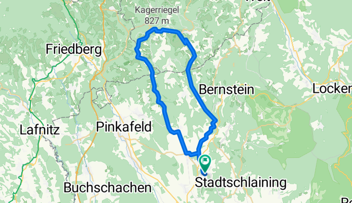
Burgenland Radtour "Panoramablick"
A cycling route starting in Bad Tatzmannsdorf, Burgenland, Austria.
Overview
About this route
<span style="font-family: Arial;">Vom Start bei der Gästeinformation Bad Tatzmannsdorf Richtung Osten in den Ortsteil Jormannsdorf entlang des Radwegs B 53. Bei der Ortsausfahrt Jormannsdorf links Richtung Pinkafeld nach Oberschützen bergauf fahren. Nach dem Ortszentrum Oberschützen rechts Richtung Willersdorf abbiegen. In der Ortsmitte links Richtung Schönherrn abbiegen und weiterfahren bis Götzendorf. Dort den Wegweiser Richtung Gschaidt beachten. In Gschaidt rechts abbiegen und bis Hochneukirchen fahren. Nach der Ortseinfahrt rechts Richtung Oberwart den Berg bis nach Tauchen hinunter fahren und an der Querstraße rechts abbiegen. Die letzten Kilometer sind wieder als Schlussteil des Radweges B 53 über Mariasdorf und Jormannsdorf gut beschildert. </span>
- -:--
- Duration
- 40.6 km
- Distance
- 659 m
- Ascent
- 659 m
- Descent
- ---
- Avg. speed
- ---
- Avg. speed
Route quality
Waytypes & surfaces along the route
Waytypes
Road
15.4 km
(38 %)
Quiet road
13.3 km
(33 %)
Surfaces
Paved
18.7 km
(46 %)
Unpaved
0.1 km
(<1 %)
Asphalt
18.7 km
(46 %)
Unpaved (undefined)
0.1 km
(<1 %)
Undefined
21.9 km
(54 %)
Continue with Bikemap
Use, edit, or download this cycling route
You would like to ride Burgenland Radtour "Panoramablick" or customize it for your own trip? Here is what you can do with this Bikemap route:
Free features
- Save this route as favorite or in collections
- Copy & plan your own version of this route
- Sync your route with Garmin or Wahoo
Premium features
Free trial for 3 days, or one-time payment. More about Bikemap Premium.
- Navigate this route on iOS & Android
- Export a GPX / KML file of this route
- Create your custom printout (try it for free)
- Download this route for offline navigation
Discover more Premium features.
Get Bikemap PremiumFrom our community
Other popular routes starting in Bad Tatzmannsdorf
 BadT_kurze Ausfahrt_Eisenzicken_St.Martin
- Distance
- 20.6 km
- Ascent
- 208 m
- Descent
- 208 m
- Location
- Bad Tatzmannsdorf, Burgenland, Austria
 Am Kurplatz 2, Bad Tatzmannsdorf nach Am Kurplatz 2, Bad Tatzmannsdorf
- Distance
- 17.6 km
- Ascent
- 28 m
- Descent
- 61 m
- Location
- Bad Tatzmannsdorf, Burgenland, Austria
 Bad Tatmannsdorf - Lockenhaus - Bad Tatzmannsdorf
- Distance
- 48.6 km
- Ascent
- 873 m
- Descent
- 874 m
- Location
- Bad Tatzmannsdorf, Burgenland, Austria
 Edelserpentinweg
- Distance
- 24.4 km
- Ascent
- 493 m
- Descent
- 494 m
- Location
- Bad Tatzmannsdorf, Burgenland, Austria
 Wilhelm-Simon-Promenade, Bad Tatzmannsdorf nach Am Golfplatz, Bad Tatzmannsdorf
- Distance
- 45.5 km
- Ascent
- 788 m
- Descent
- 785 m
- Location
- Bad Tatzmannsdorf, Burgenland, Austria
 Bad Tatzmannsdorf-Vier Jahresz. Radweg-Paradiesroute- Bahntrassenradweg
- Distance
- 63.7 km
- Ascent
- 567 m
- Descent
- 567 m
- Location
- Bad Tatzmannsdorf, Burgenland, Austria
 BadT_ganz kurze Ausfahrt_St.Martin
- Distance
- 18.2 km
- Ascent
- 151 m
- Descent
- 153 m
- Location
- Bad Tatzmannsdorf, Burgenland, Austria
 BT Bahntrassenwegrunde bis Burg
- Distance
- 58.3 km
- Ascent
- 496 m
- Descent
- 503 m
- Location
- Bad Tatzmannsdorf, Burgenland, Austria
Open it in the app