

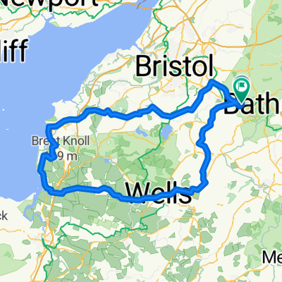
45km ride from Bath Odd Down Park and Ride, to North then East of Bath, returning up Summer Lane
A cycling route starting in Bath, England, United Kingdom.
Overview
About this route
Decent amount of climbing (Bikemap = 640m, Strava = 738m)
- -:--
- Duration
- 44.9 km
- Distance
- 564 m
- Ascent
- 563 m
- Descent
- ---
- Avg. speed
- ---
- Avg. speed

Route quality
Waytypes & surfaces along the route
Waytypes
Busy road
19.6 km
(44 %)
Road
10.8 km
(24 %)
Surfaces
Paved
32 km
(71 %)
Asphalt
32 km
(71 %)
Undefined
12.9 km
(29 %)
Continue with Bikemap
Use, edit, or download this cycling route
You would like to ride 45km ride from Bath Odd Down Park and Ride, to North then East of Bath, returning up Summer Lane or customize it for your own trip? Here is what you can do with this Bikemap route:
Free features
- Save this route as favorite or in collections
- Copy & plan your own version of this route
- Sync your route with Garmin or Wahoo
Premium features
Free trial for 3 days, or one-time payment. More about Bikemap Premium.
- Navigate this route on iOS & Android
- Export a GPX / KML file of this route
- Create your custom printout (try it for free)
- Download this route for offline navigation
Discover more Premium features.
Get Bikemap PremiumFrom our community
Other popular routes starting in Bath
 Bath 010
- Distance
- 138.8 km
- Ascent
- 627 m
- Descent
- 633 m
- Location
- Bath, England, United Kingdom
 Bath 004
- Distance
- 103.2 km
- Ascent
- 503 m
- Descent
- 498 m
- Location
- Bath, England, United Kingdom
 Two Tunnels And Combe Hay
- Distance
- 17.5 km
- Ascent
- 421 m
- Descent
- 279 m
- Location
- Bath, England, United Kingdom
 40km circular
- Distance
- 40 km
- Ascent
- 430 m
- Descent
- 433 m
- Location
- Bath, England, United Kingdom
 Route1
- Distance
- 14.5 km
- Ascent
- 255 m
- Descent
- 258 m
- Location
- Bath, England, United Kingdom
 From Bath to Wincanton
- Distance
- 65.4 km
- Ascent
- 725 m
- Descent
- 677 m
- Location
- Bath, England, United Kingdom
 Bike Bath 80 Mile
- Distance
- 127.3 km
- Ascent
- 762 m
- Descent
- 761 m
- Location
- Bath, England, United Kingdom
 Bath - Bourton on the Water
- Distance
- 105.3 km
- Ascent
- 879 m
- Descent
- 783 m
- Location
- Bath, England, United Kingdom
Open it in the app