

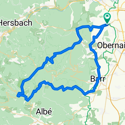
Rosheim - St Odile - Gendelbruch - Rosheim
A cycling route starting in Rosheim, Alsace-Champagne-Ardenne-Lorraine, France.
Overview
About this route
Un peu d'échauffement avant d'attaquer la côte de St Odile - descente puis remontée dans les bois et descente vers Gendrelbruch er Rosheim.
- -:--
- Duration
- 48.5 km
- Distance
- 916 m
- Ascent
- 916 m
- Descent
- ---
- Avg. speed
- ---
- Avg. speed
Route quality
Waytypes & surfaces along the route
Waytypes
Busy road
31.3 km
(64 %)
Road
11.6 km
(24 %)
Surfaces
Paved
18.5 km
(38 %)
Unpaved
3.8 km
(8 %)
Asphalt
18.5 km
(38 %)
Gravel
2.6 km
(5 %)
Continue with Bikemap
Use, edit, or download this cycling route
You would like to ride Rosheim - St Odile - Gendelbruch - Rosheim or customize it for your own trip? Here is what you can do with this Bikemap route:
Free features
- Save this route as favorite or in collections
- Copy & plan your own version of this route
- Sync your route with Garmin or Wahoo
Premium features
Free trial for 3 days, or one-time payment. More about Bikemap Premium.
- Navigate this route on iOS & Android
- Export a GPX / KML file of this route
- Create your custom printout (try it for free)
- Download this route for offline navigation
Discover more Premium features.
Get Bikemap PremiumFrom our community
Other popular routes starting in Rosheim
 EDK 2016
- Distance
- 22.8 km
- Ascent
- 656 m
- Descent
- 654 m
- Location
- Rosheim, Alsace-Champagne-Ardenne-Lorraine, France
 cinderella
- Distance
- 35.2 km
- Ascent
- 75 m
- Descent
- 150 m
- Location
- Rosheim, Alsace-Champagne-Ardenne-Lorraine, France
 De Rue du Maire Schaffner 2, Rosheim à Rue du Maire Schaffner 1, Rosheim
- Distance
- 35.1 km
- Ascent
- 8 m
- Descent
- 13 m
- Location
- Rosheim, Alsace-Champagne-Ardenne-Lorraine, France
 La Magel à partir de Rosheim
- Distance
- 38.4 km
- Ascent
- 757 m
- Descent
- 760 m
- Location
- Rosheim, Alsace-Champagne-Ardenne-Lorraine, France
 Cote mille - Bruche - Champ de Feu - Odile
- Distance
- 88.7 km
- Ascent
- 1,814 m
- Descent
- 1,814 m
- Location
- Rosheim, Alsace-Champagne-Ardenne-Lorraine, France
 Rosheim Kreuzweg Champ de Feu
- Distance
- 63.6 km
- Ascent
- 1,436 m
- Descent
- 1,295 m
- Location
- Rosheim, Alsace-Champagne-Ardenne-Lorraine, France
 Rosheim - Strassburg
- Distance
- 34.1 km
- Ascent
- 109 m
- Descent
- 150 m
- Location
- Rosheim, Alsace-Champagne-Ardenne-Lorraine, France
 Rosheim-Boersch-Ottrot-Odilienberg
- Distance
- 12 km
- Ascent
- 627 m
- Descent
- 54 m
- Location
- Rosheim, Alsace-Champagne-Ardenne-Lorraine, France
Open it in the app