
Ulm-Berlin (Etappe 5)
A cycling route starting in Tettau, Bavaria, Germany.
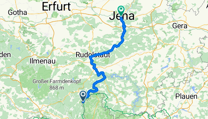
Overview
About this route
- -:--
- Duration
- 97.5 km
- Distance
- 204 m
- Ascent
- 674 m
- Descent
- ---
- Avg. speed
- ---
- Avg. speed

Route quality
Waytypes & surfaces along the route
Waytypes
Busy road
36.7 km
(38 %)
Quiet road
19.4 km
(20 %)
Surfaces
Paved
63.4 km
(65 %)
Unpaved
4.3 km
(4 %)
Asphalt
61.4 km
(63 %)
Gravel
2.7 km
(3 %)
Continue with Bikemap
Use, edit, or download this cycling route
You would like to ride Ulm-Berlin (Etappe 5) or customize it for your own trip? Here is what you can do with this Bikemap route:
Free features
- Save this route as favorite or in collections
- Copy & plan your own version of this route
- Sync your route with Garmin or Wahoo
Premium features
Free trial for 3 days, or one-time payment. More about Bikemap Premium.
- Navigate this route on iOS & Android
- Export a GPX / KML file of this route
- Create your custom printout (try it for free)
- Download this route for offline navigation
Discover more Premium features.
Get Bikemap PremiumFrom our community
Other popular routes starting in Tettau
 Unterhalb von Lichtenhain :)
- Distance
- 24 km
- Ascent
- 625 m
- Descent
- 625 m
- Location
- Tettau, Bavaria, Germany
 zwischen Thüringer Wald und Schiefergebirge
- Distance
- 68.1 km
- Ascent
- 844 m
- Descent
- 1,023 m
- Location
- Tettau, Bavaria, Germany
 In den Wäldern bei Kleintettau
- Distance
- 29.3 km
- Ascent
- 392 m
- Descent
- 392 m
- Location
- Tettau, Bavaria, Germany
 Rennsteig, -Loquitztal - Taugwitztal
- Distance
- 25.6 km
- Ascent
- 435 m
- Descent
- 413 m
- Location
- Tettau, Bavaria, Germany
 RVC-Tour Talsperre Leibis ab Kalte Küche
- Distance
- 46.8 km
- Ascent
- 889 m
- Descent
- 892 m
- Location
- Tettau, Bavaria, Germany
 Tettau Neuhaus Schwarzatal Saalfeld
- Distance
- 64.7 km
- Ascent
- 674 m
- Descent
- 1,082 m
- Location
- Tettau, Bavaria, Germany
 Rund um Hasenthal
- Distance
- 21.5 km
- Ascent
- 546 m
- Descent
- 523 m
- Location
- Tettau, Bavaria, Germany
 20-8-14 Vom Rennsteig nach Kronach
- Distance
- 31.7 km
- Ascent
- 19 m
- Descent
- 369 m
- Location
- Tettau, Bavaria, Germany
Open it in the app