

Memphis - Greenville
A cycling route starting in Memphis, Tennessee, United States of America.
Overview
About this route
- -:--
- Duration
- 247.2 km
- Distance
- 46 m
- Ascent
- 79 m
- Descent
- ---
- Avg. speed
- ---
- Avg. speed
Route quality
Waytypes & surfaces along the route
Waytypes
Busy road
86.7 km
(35 %)
Quiet road
74.1 km
(30 %)
Surfaces
Paved
123.5 km
(50 %)
Unpaved
4.5 km
(2 %)
Asphalt
123.5 km
(50 %)
Gravel
4.5 km
(2 %)
Undefined
119.1 km
(48 %)
Continue with Bikemap
Use, edit, or download this cycling route
You would like to ride Memphis - Greenville or customize it for your own trip? Here is what you can do with this Bikemap route:
Free features
- Save this route as favorite or in collections
- Copy & plan your own version of this route
- Sync your route with Garmin or Wahoo
Premium features
Free trial for 3 days, or one-time payment. More about Bikemap Premium.
- Navigate this route on iOS & Android
- Export a GPX / KML file of this route
- Create your custom printout (try it for free)
- Download this route for offline navigation
Discover more Premium features.
Get Bikemap PremiumFrom our community
Other popular routes starting in Memphis
 27 May 2020 NIGHT
- Distance
- 9.6 km
- Ascent
- 44 m
- Descent
- 43 m
- Location
- Memphis, Tennessee, United States of America
 downtown Main Street
- Distance
- 6 km
- Ascent
- 73 m
- Descent
- 80 m
- Location
- Memphis, Tennessee, United States of America
 Steady ride in Memphis
- Distance
- 14.4 km
- Ascent
- 293 m
- Descent
- 278 m
- Location
- Memphis, Tennessee, United States of America
 125 N Front St, Memphis to 140–144 AR-14, Lead Hill
- Distance
- 404.4 km
- Ascent
- 2,596 m
- Descent
- 2,422 m
- Location
- Memphis, Tennessee, United States of America
 downtown/big river
- Distance
- 13.5 km
- Ascent
- 172 m
- Descent
- 172 m
- Location
- Memphis, Tennessee, United States of America
 RiverCross
- Distance
- 66 km
- Ascent
- 52 m
- Descent
- 52 m
- Location
- Memphis, Tennessee, United States of America
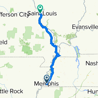 Memphis to St.Louis
- Distance
- 531.9 km
- Ascent
- 2,357 m
- Descent
- 2,295 m
- Location
- Memphis, Tennessee, United States of America
 Memphis to Cherokee for Natchez Trace
- Distance
- 274.7 km
- Ascent
- 2,226 m
- Descent
- 2,158 m
- Location
- Memphis, Tennessee, United States of America
Open it in the app