

Ravensburg - Köpfingen - Frohe Aussicht - Runde
A cycling route starting in Ravensburg, Baden-Württemberg, Germany.
Overview
About this route
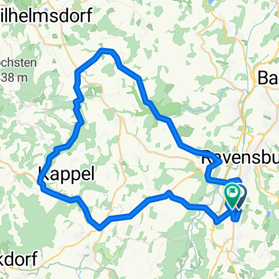
Schöne Tour durch die Höll in Ravensburg Richtung Berg. Dann durch Weingarten nach Briach und Köpfingen. Hier kann man schön in der Gartenwirtschaft Frohe Aussicht einkehren. In der Tat ist das hier eine Hammer Aussicht (siehe Bild). Der Rückweg bleibt auf dieser Höhe und geht Richtung Schlier. Von dort abseits der großen Straße durch den Wald zurück nach Ravensburg.
Schreibt mir Eure Kommentare, wenn Ihr die Tour gefahren seid.
- -:--
- Duration
- 32.1 km
- Distance
- 444 m
- Ascent
- 430 m
- Descent
- ---
- Avg. speed
- 609 m
- Avg. speed

Route quality
Waytypes & surfaces along the route
Waytypes
Quiet road
18.7 km
(58 %)
Path
4.5 km
(14 %)
Surfaces
Paved
27.7 km
(86 %)
Unpaved
2 km
(6 %)
Asphalt
27.3 km
(85 %)
Gravel
1.2 km
(4 %)
Continue with Bikemap
Use, edit, or download this cycling route
You would like to ride Ravensburg - Köpfingen - Frohe Aussicht - Runde or customize it for your own trip? Here is what you can do with this Bikemap route:
Free features
- Save this route as favorite or in collections
- Copy & plan your own version of this route
- Sync your route with Garmin or Wahoo
Premium features
Free trial for 3 days, or one-time payment. More about Bikemap Premium.
- Navigate this route on iOS & Android
- Export a GPX / KML file of this route
- Create your custom printout (try it for free)
- Download this route for offline navigation
Discover more Premium features.
Get Bikemap PremiumFrom our community
Other popular routes starting in Ravensburg
 RV_Kressbronn_Selmnau_Tettnang_RV
- Distance
- 54.7 km
- Ascent
- 366 m
- Descent
- 366 m
- Location
- Ravensburg, Baden-Württemberg, Germany
 Von Ravensburg nach Meersburg
- Distance
- 29.6 km
- Ascent
- 264 m
- Descent
- 288 m
- Location
- Ravensburg, Baden-Württemberg, Germany
 Von Ravensburg zum Pfrunger Ried
- Distance
- 75.9 km
- Ascent
- 494 m
- Descent
- 494 m
- Location
- Ravensburg, Baden-Württemberg, Germany
 RV_GehrenbergTurm_RV
- Distance
- 62.8 km
- Ascent
- 462 m
- Descent
- 464 m
- Location
- Ravensburg, Baden-Württemberg, Germany
 Von Ravensburg nach Konstanz
- Distance
- 50.2 km
- Ascent
- 356 m
- Descent
- 389 m
- Location
- Ravensburg, Baden-Württemberg, Germany
 Von Ravensburg nach Friedrichshafen - Sommerweg
- Distance
- 20.5 km
- Ascent
- 68 m
- Descent
- 94 m
- Location
- Ravensburg, Baden-Württemberg, Germany
 Tobeltour
- Distance
- 49.3 km
- Ascent
- 629 m
- Descent
- 616 m
- Location
- Ravensburg, Baden-Württemberg, Germany
 Burg Fronhofen - Bibersee - Runde
- Distance
- 34.3 km
- Ascent
- 418 m
- Descent
- 421 m
- Location
- Ravensburg, Baden-Württemberg, Germany
Open it in the app