

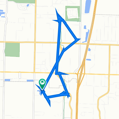
Coler Trailhead — Posy Mtn. Loop
A cycling route starting in Bentonville, Arkansas, United States of America.
Overview
About this route
- 4 h 26 min
- Duration
- 78.9 km
- Distance
- 363 m
- Ascent
- 365 m
- Descent
- 17.8 km/h
- Avg. speed
- ---
- Avg. speed

Route quality
Waytypes & surfaces along the route
Waytypes
Quiet road
53.3 km
(68 %)
Road
19.9 km
(25 %)
Surfaces
Paved
21.9 km
(28 %)
Unpaved
6 km
(8 %)
Paved (undefined)
14.2 km
(18 %)
Asphalt
7.6 km
(10 %)
Continue with Bikemap
Use, edit, or download this cycling route
You would like to ride Coler Trailhead — Posy Mtn. Loop or customize it for your own trip? Here is what you can do with this Bikemap route:
Free features
- Save this route as favorite or in collections
- Copy & plan your own version of this route
- Sync your route with Garmin or Wahoo
Premium features
Free trial for 3 days, or one-time payment. More about Bikemap Premium.
- Navigate this route on iOS & Android
- Export a GPX / KML file of this route
- Create your custom printout (try it for free)
- Download this route for offline navigation
Discover more Premium features.
Get Bikemap PremiumFrom our community
Other popular routes starting in Bentonville
 BIkePOC Route
- Distance
- 50.2 km
- Ascent
- 445 m
- Descent
- 448 m
- Location
- Bentonville, Arkansas, United States of America
 from buckey ball to home
- Distance
- 3 km
- Ascent
- 4 m
- Descent
- 5 m
- Location
- Bentonville, Arkansas, United States of America
 BRR to Pumphouse
- Distance
- 2.9 km
- Ascent
- 16 m
- Descent
- 17 m
- Location
- Bentonville, Arkansas, United States of America
 Pea Ridge 28
- Distance
- 45.4 km
- Ascent
- 351 m
- Descent
- 352 m
- Location
- Bentonville, Arkansas, United States of America
 Bentonville Home Route
- Distance
- 42 km
- Ascent
- 168 m
- Descent
- 168 m
- Location
- Bentonville, Arkansas, United States of America
 Route to 503 Drake St, Bentonville
- Distance
- 18.7 km
- Ascent
- 73 m
- Descent
- 66 m
- Location
- Bentonville, Arkansas, United States of America
 South Dodson Road 513, Rogers to South Dodson Road 513, Rogers
- Distance
- 7.2 km
- Ascent
- 4 m
- Descent
- 4 m
- Location
- Bentonville, Arkansas, United States of America
 Bike Shop to Coler Mtb Preserve/Osage Park
- Distance
- 19.7 km
- Ascent
- 113 m
- Descent
- 118 m
- Location
- Bentonville, Arkansas, United States of America
Open it in the app