

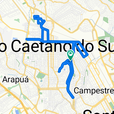
De Rua Manuel Luiz de Araújo Costa 285 a Rua Manuel Luiz de Araújo Costa 289
A cycling route starting in São Caetano do Sul, São Paulo, Brazil.
Overview
About this route
- 1 h 51 min
- Duration
- 19.4 km
- Distance
- 192 m
- Ascent
- 198 m
- Descent
- 10.5 km/h
- Avg. speed
- ---
- Avg. speed

Route photos

Continue with Bikemap
Use, edit, or download this cycling route
You would like to ride De Rua Manuel Luiz de Araújo Costa 285 a Rua Manuel Luiz de Araújo Costa 289 or customize it for your own trip? Here is what you can do with this Bikemap route:
Free features
- Save this route as favorite or in collections
- Copy & plan your own version of this route
- Sync your route with Garmin or Wahoo
Premium features
Free trial for 3 days, or one-time payment. More about Bikemap Premium.
- Navigate this route on iOS & Android
- Export a GPX / KML file of this route
- Create your custom printout (try it for free)
- Download this route for offline navigation
Discover more Premium features.
Get Bikemap PremiumFrom our community
Other popular routes starting in São Caetano do Sul
 Alternativa Segunda-Feira 2
- Distance
- 19.1 km
- Ascent
- 143 m
- Descent
- 144 m
- Location
- São Caetano do Sul, São Paulo, Brazil
 De Rua Correia Barros 300 a Rua Cabo Gastão Gama 175
- Distance
- 11.8 km
- Ascent
- 263 m
- Descent
- 149 m
- Location
- São Caetano do Sul, São Paulo, Brazil
 Domingo 26.02 De Rua Alberto Romani Horta 169 a Avenida Professor Luiz Ignácio Anhaia Mello 3660
- Distance
- 3.6 km
- Ascent
- 31 m
- Descent
- 30 m
- Location
- São Caetano do Sul, São Paulo, Brazil
 Sacomã ~Ciclovia Marginal
- Distance
- 11.7 km
- Ascent
- 129 m
- Descent
- 188 m
- Location
- São Caetano do Sul, São Paulo, Brazil
 Loop São Caetano x São Bernardo
- Distance
- 32.3 km
- Ascent
- 191 m
- Descent
- 190 m
- Location
- São Caetano do Sul, São Paulo, Brazil
 De Rua Palmeira Bacaba 277 a Rua Alfavaca 81
- Distance
- 76.5 km
- Ascent
- 445 m
- Descent
- 495 m
- Location
- São Caetano do Sul, São Paulo, Brazil
 Metrô Vila Prudente - Ciclovia Adutora Rio Claro
- Distance
- 6.7 km
- Ascent
- 149 m
- Descent
- 93 m
- Location
- São Caetano do Sul, São Paulo, Brazil
 Av. Aricanduva - Av. Paulista / Praça do Ciclista
- Distance
- 23 km
- Ascent
- 1,665 m
- Descent
- 1,634 m
- Location
- São Caetano do Sul, São Paulo, Brazil
Open it in the app