

Donauradweg-St.Martin-Haslach-Breitenberg2
A cycling route starting in Untergriesbach, Bavaria, Germany.
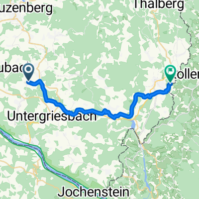
Overview
About this route
- -:--
- Duration
- 136.1 km
- Distance
- 1,085 m
- Ascent
- 1,087 m
- Descent
- ---
- Avg. speed
- ---
- Avg. speed
Route quality
Waytypes & surfaces along the route
Waytypes
Busy road
67.5 km
(50 %)
Road
38.7 km
(28 %)
Surfaces
Paved
71.9 km
(53 %)
Unpaved
3.9 km
(3 %)
Asphalt
70 km
(51 %)
Ground
3.3 km
(2 %)
Continue with Bikemap
Use, edit, or download this cycling route
You would like to ride Donauradweg-St.Martin-Haslach-Breitenberg2 or customize it for your own trip? Here is what you can do with this Bikemap route:
Free features
- Save this route as favorite or in collections
- Copy & plan your own version of this route
- Sync your route with Garmin or Wahoo
Premium features
Free trial for 3 days, or one-time payment. More about Bikemap Premium.
- Navigate this route on iOS & Android
- Export a GPX / KML file of this route
- Create your custom printout (try it for free)
- Download this route for offline navigation
Discover more Premium features.
Get Bikemap PremiumFrom our community
Other popular routes starting in Untergriesbach
 031 - 2014
- Distance
- 77.2 km
- Ascent
- 937 m
- Descent
- 1,007 m
- Location
- Untergriesbach, Bavaria, Germany
 Zum Aidenberger Lusen
- Distance
- 19.4 km
- Ascent
- 517 m
- Descent
- 290 m
- Location
- Untergriesbach, Bavaria, Germany
 Wegscheid-Sonnen-Hauzenberg
- Distance
- 48.1 km
- Ascent
- 695 m
- Descent
- 734 m
- Location
- Untergriesbach, Bavaria, Germany
 Gemütliche Route in Untergriesbach
- Distance
- 25.2 km
- Ascent
- 837 m
- Descent
- 662 m
- Location
- Untergriesbach, Bavaria, Germany
 Untergriesbach - Panorama Radweg
- Distance
- 39.3 km
- Ascent
- 672 m
- Descent
- 672 m
- Location
- Untergriesbach, Bavaria, Germany
 Moderate Route in Wegscheid
- Distance
- 17.8 km
- Ascent
- 724 m
- Descent
- 599 m
- Location
- Untergriesbach, Bavaria, Germany
 St 2319, Untergriesbach nach Eggersdorfer Straße, Thyrnau
- Distance
- 13 km
- Ascent
- 308 m
- Descent
- 335 m
- Location
- Untergriesbach, Bavaria, Germany
 Hauzenberger Straße 5, Untergriesbach nach B388, Obernzell
- Distance
- 7.3 km
- Ascent
- 239 m
- Descent
- 331 m
- Location
- Untergriesbach, Bavaria, Germany
Open it in the app