
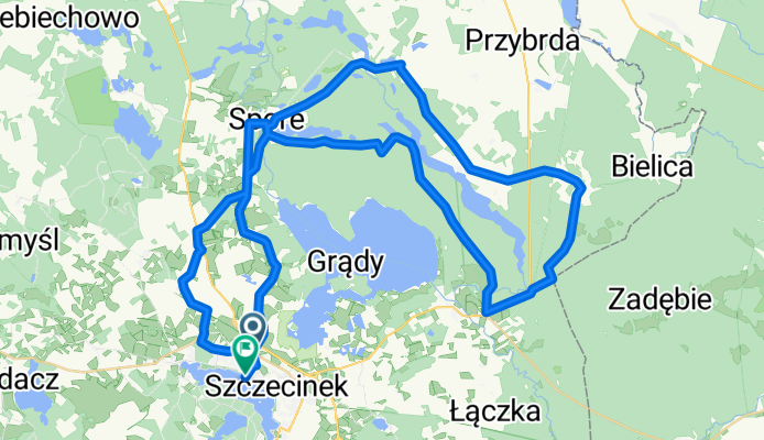
Trasa 13
A cycling route starting in Szczecinek, West Pomeranian Voivodeship, Poland.
Overview
About this route
Statistics calculated from imported data
Distance: 64.6 km Minimum elevation: 168 m Maximum elevation: 203 m Total ascent: 73 m Total descent: 105 m
- -:--
- Duration
- 61.8 km
- Distance
- 196 m
- Ascent
- 194 m
- Descent
- ---
- Avg. speed
- ---
- Max. altitude
Route quality
Waytypes & surfaces along the route
Waytypes
Track
34.6 km
(56 %)
Road
13.6 km
(22 %)
Surfaces
Paved
19.2 km
(31 %)
Unpaved
24.1 km
(39 %)
Asphalt
17.3 km
(28 %)
Ground
16.7 km
(27 %)
Continue with Bikemap
Use, edit, or download this cycling route
You would like to ride Trasa 13 or customize it for your own trip? Here is what you can do with this Bikemap route:
Free features
- Save this route as favorite or in collections
- Copy & plan your own version of this route
- Sync your route with Garmin or Wahoo
Premium features
Free trial for 3 days, or one-time payment. More about Bikemap Premium.
- Navigate this route on iOS & Android
- Export a GPX / KML file of this route
- Create your custom printout (try it for free)
- Download this route for offline navigation
Discover more Premium features.
Get Bikemap PremiumFrom our community
Other popular routes starting in Szczecinek
 Trasa 5
- Distance
- 28.4 km
- Ascent
- 94 m
- Descent
- 94 m
- Location
- Szczecinek, West Pomeranian Voivodeship, Poland
 Poland with SKT
- Distance
- 207.1 km
- Ascent
- 1,294 m
- Descent
- 1,328 m
- Location
- Szczecinek, West Pomeranian Voivodeship, Poland
 Trasa 10
- Distance
- 57.4 km
- Ascent
- 125 m
- Descent
- 125 m
- Location
- Szczecinek, West Pomeranian Voivodeship, Poland
 Trasa 13
- Distance
- 61.8 km
- Ascent
- 196 m
- Descent
- 194 m
- Location
- Szczecinek, West Pomeranian Voivodeship, Poland
 Trasa 8
- Distance
- 40.8 km
- Ascent
- 5 m
- Descent
- 0 m
- Location
- Szczecinek, West Pomeranian Voivodeship, Poland
 Szlak czerwony "Szczecineckie Jeziora"
- Distance
- 62.6 km
- Ascent
- 168 m
- Descent
- 169 m
- Location
- Szczecinek, West Pomeranian Voivodeship, Poland
 Szlak Nizica czarny rowerowy
- Distance
- 43.1 km
- Ascent
- 129 m
- Descent
- 131 m
- Location
- Szczecinek, West Pomeranian Voivodeship, Poland
 Sowia 5, Szczecinek do Aleja Niepodległości 49, Borne Sulinowo
- Distance
- 25.2 km
- Ascent
- 113 m
- Descent
- 113 m
- Location
- Szczecinek, West Pomeranian Voivodeship, Poland
Open it in the app