

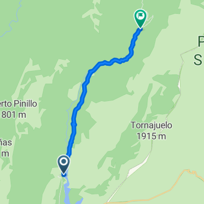
Rambla Seca-FAcero-Vado-FAcero
A cycling route starting in Castril, Andalusia, Spain.
Overview
About this route
- -:--
- Duration
- 26.4 km
- Distance
- 464 m
- Ascent
- 560 m
- Descent
- ---
- Avg. speed
- ---
- Avg. speed
Route quality
Waytypes & surfaces along the route
Waytypes
Track
26.4 km
(100 %)
Surfaces
Unpaved
26.4 km
(100 %)
Gravel
15.4 km
(58 %)
Unpaved (undefined)
11 km
(42 %)
Undefined
0 km
(<1 %)
Continue with Bikemap
Use, edit, or download this cycling route
You would like to ride Rambla Seca-FAcero-Vado-FAcero or customize it for your own trip? Here is what you can do with this Bikemap route:
Free features
- Save this route as favorite or in collections
- Copy & plan your own version of this route
- Sync your route with Garmin or Wahoo
Premium features
Free trial for 3 days, or one-time payment. More about Bikemap Premium.
- Navigate this route on iOS & Android
- Export a GPX / KML file of this route
- Create your custom printout (try it for free)
- Download this route for offline navigation
Discover more Premium features.
Get Bikemap PremiumFrom our community
Other popular routes starting in Castril
 Castril-La Matea (Santiago-Pontones)
- Distance
- 64.9 km
- Ascent
- 1,397 m
- Descent
- 979 m
- Location
- Castril, Andalusia, Spain
 Subida desde Castril al nacimiento del rio
- Distance
- 17.8 km
- Ascent
- 652 m
- Descent
- 247 m
- Location
- Castril, Andalusia, Spain
 circular campos hernan perea
- Distance
- 46.4 km
- Ascent
- 499 m
- Descent
- 499 m
- Location
- Castril, Andalusia, Spain
 Embalses del Portillo y San Clemente
- Distance
- 62.5 km
- Ascent
- 655 m
- Descent
- 648 m
- Location
- Castril, Andalusia, Spain
 Et 1 Castril - Zújar
- Distance
- 45.9 km
- Ascent
- 430 m
- Descent
- 512 m
- Location
- Castril, Andalusia, Spain
 Bolera - Bolera por Guadalentín túneles, Roblehondo, Los Calarejos, Nava de San Pedro.
- Distance
- 70.3 km
- Ascent
- 2,839 m
- Descent
- 2,844 m
- Location
- Castril, Andalusia, Spain
 Sierras del Pozo y Segura
- Distance
- 58.8 km
- Ascent
- 1,979 m
- Descent
- 1,979 m
- Location
- Castril, Andalusia, Spain
 Cortijo del Molinillo - Casa Forestal del Barranco del Guadalentin
- Distance
- 12.9 km
- Ascent
- 456 m
- Descent
- 207 m
- Location
- Castril, Andalusia, Spain
Open it in the app