

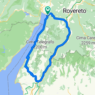
Garda felső kör
A cycling route starting in Torbole sul Garda, Trentino-Alto Adige, Italy.
Overview
About this route
- -:--
- Duration
- 36.2 km
- Distance
- 336 m
- Ascent
- 333 m
- Descent
- ---
- Avg. speed
- ---
- Max. altitude

Route quality
Waytypes & surfaces along the route
Waytypes
Quiet road
7.6 km
(21 %)
Cycleway
6.2 km
(17 %)
Surfaces
Paved
29.3 km
(81 %)
Asphalt
27.1 km
(75 %)
Concrete
1.1 km
(3 %)
Continue with Bikemap
Use, edit, or download this cycling route
You would like to ride Garda felső kör or customize it for your own trip? Here is what you can do with this Bikemap route:
Free features
- Save this route as favorite or in collections
- Copy & plan your own version of this route
- Sync your route with Garmin or Wahoo
Premium features
Free trial for 3 days, or one-time payment. More about Bikemap Premium.
- Navigate this route on iOS & Android
- Export a GPX / KML file of this route
- Create your custom printout (try it for free)
- Download this route for offline navigation
Discover more Premium features.
Get Bikemap PremiumFrom our community
Other popular routes starting in Torbole sul Garda
 Torbole - S.Giovanni
- Distance
- 40.2 km
- Ascent
- 1,110 m
- Descent
- 1,112 m
- Location
- Torbole sul Garda, Trentino-Alto Adige, Italy
 so aco
- Distance
- 119.3 km
- Ascent
- 1,725 m
- Descent
- 1,722 m
- Location
- Torbole sul Garda, Trentino-Alto Adige, Italy
 Torbole - Duron und retour
- Distance
- 59.3 km
- Ascent
- 1,258 m
- Descent
- 1,258 m
- Location
- Torbole sul Garda, Trentino-Alto Adige, Italy
 Via Benaco nach Piazzale Paolo Orsi
- Distance
- 20.1 km
- Ascent
- 262 m
- Descent
- 193 m
- Location
- Torbole sul Garda, Trentino-Alto Adige, Italy
 Torbole - C.Veronese - Mte. san Zeno
- Distance
- 94.7 km
- Ascent
- 929 m
- Descent
- 953 m
- Location
- Torbole sul Garda, Trentino-Alto Adige, Italy
 Monte Bondone I
- Distance
- 110.5 km
- Ascent
- 2,404 m
- Descent
- 2,403 m
- Location
- Torbole sul Garda, Trentino-Alto Adige, Italy
 Torbole_Arco_Mte.Baone_Arco_Riva
- Distance
- 23.6 km
- Ascent
- 418 m
- Descent
- 401 m
- Location
- Torbole sul Garda, Trentino-Alto Adige, Italy
 Garda felső kör
- Distance
- 36.2 km
- Ascent
- 336 m
- Descent
- 333 m
- Location
- Torbole sul Garda, Trentino-Alto Adige, Italy
Open it in the app