
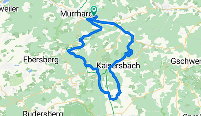
Alm-Kaisersbach-Aichstrutsee-Ebnisee-Sechselberg-Alm
A cycling route starting in Murrhardt, Baden-Württemberg, Germany.
Overview
About this route
Anstrengend, ca. 600 Höhemeter. Ca. 3,5 Std. unterwegs Gefahren am 12.07.2020
- -:--
- Duration
- 33.5 km
- Distance
- 614 m
- Ascent
- 611 m
- Descent
- ---
- Avg. speed
- ---
- Avg. speed
Route quality
Waytypes & surfaces along the route
Waytypes
Track
15.8 km
(47 %)
Quiet road
5.9 km
(17 %)
Surfaces
Paved
16.8 km
(50 %)
Unpaved
11.5 km
(34 %)
Asphalt
15.6 km
(46 %)
Gravel
11.2 km
(33 %)
Continue with Bikemap
Use, edit, or download this cycling route
You would like to ride Alm-Kaisersbach-Aichstrutsee-Ebnisee-Sechselberg-Alm or customize it for your own trip? Here is what you can do with this Bikemap route:
Free features
- Save this route as favorite or in collections
- Copy & plan your own version of this route
- Sync your route with Garmin or Wahoo
Premium features
Free trial for 3 days, or one-time payment. More about Bikemap Premium.
- Navigate this route on iOS & Android
- Export a GPX / KML file of this route
- Create your custom printout (try it for free)
- Download this route for offline navigation
Discover more Premium features.
Get Bikemap PremiumFrom our community
Other popular routes starting in Murrhardt
 Murrhardt Mountainbike Rundkurs No 3
- Distance
- 34.3 km
- Ascent
- 662 m
- Descent
- 662 m
- Location
- Murrhardt, Baden-Württemberg, Germany
 Rund um Murrhardt
- Distance
- 43.8 km
- Ascent
- 1,023 m
- Descent
- 914 m
- Location
- Murrhardt, Baden-Württemberg, Germany
 Trekking Rad Rundfahrt Ebnisee, Kaisersbach, Kiki, Murrhardt
- Distance
- 37.5 km
- Ascent
- 548 m
- Descent
- 549 m
- Location
- Murrhardt, Baden-Württemberg, Germany
 Murrhardt-Backnang-Ebersberg-Murrhardt 21.02.21
- Distance
- 43.6 km
- Ascent
- 459 m
- Descent
- 456 m
- Location
- Murrhardt, Baden-Württemberg, Germany
 Limesrunde 20.02.21
- Distance
- 49.2 km
- Ascent
- 628 m
- Descent
- 632 m
- Location
- Murrhardt, Baden-Württemberg, Germany
 Mönchsberg
- Distance
- 36 km
- Ascent
- 550 m
- Descent
- 515 m
- Location
- Murrhardt, Baden-Württemberg, Germany
 Afterwork- Trekking- Tour Murrhardt-Eschelhof- Zell- Murrhardt
- Distance
- 27.3 km
- Ascent
- 575 m
- Descent
- 576 m
- Location
- Murrhardt, Baden-Württemberg, Germany
 Römerritt / Bin Radeln 3
- Distance
- 27.3 km
- Ascent
- 604 m
- Descent
- 604 m
- Location
- Murrhardt, Baden-Württemberg, Germany
Open it in the app