

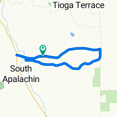
Tracy Creek Loop
A cycling route starting in Apalachin, New York, United States of America.
Overview
About this route
- 1 h 16 min
- Duration
- 22.6 km
- Distance
- 500 m
- Ascent
- 526 m
- Descent
- 17.9 km/h
- Avg. speed
- ---
- Avg. speed
Route quality
Waytypes & surfaces along the route
Waytypes
Road
9.2 km
(41 %)
Busy road
9 km
(40 %)
Surfaces
Paved
15.7 km
(70 %)
Asphalt
13.4 km
(59 %)
Paved (undefined)
2.2 km
(10 %)
Continue with Bikemap
Use, edit, or download this cycling route
You would like to ride Tracy Creek Loop or customize it for your own trip? Here is what you can do with this Bikemap route:
Free features
- Save this route as favorite or in collections
- Copy & plan your own version of this route
- Sync your route with Garmin or Wahoo
Premium features
Free trial for 3 days, or one-time payment. More about Bikemap Premium.
- Navigate this route on iOS & Android
- Export a GPX / KML file of this route
- Create your custom printout (try it for free)
- Download this route for offline navigation
Discover more Premium features.
Get Bikemap PremiumFrom our community
Other popular routes starting in Apalachin
 NY-434, Apalachin to Park St, Endicott
- Distance
- 29.4 km
- Ascent
- 179 m
- Descent
- 182 m
- Location
- Apalachin, New York, United States of America
 Tracy Creek Loop
- Distance
- 22.6 km
- Ascent
- 500 m
- Descent
- 526 m
- Location
- Apalachin, New York, United States of America
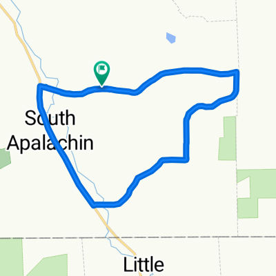
 Apalachin PA Trail
- Distance
- 24.5 km
- Ascent
- 611 m
- Descent
- 617 m
- Location
- Apalachin, New York, United States of America
 Apalachin Trail
- Distance
- 12 km
- Ascent
- 347 m
- Descent
- 369 m
- Location
- Apalachin, New York, United States of America
 NY-434, Apalachin to NY-434, Apalachin
- Distance
- 27.9 km
- Ascent
- 141 m
- Descent
- 141 m
- Location
- Apalachin, New York, United States of America
 NY-434, Apalachin to NY-434, Apalachin
- Distance
- 28 km
- Ascent
- 432 m
- Descent
- 248 m
- Location
- Apalachin, New York, United States of America
 Lillie Hill to Penn Ave
- Distance
- 16.2 km
- Ascent
- 375 m
- Descent
- 380 m
- Location
- Apalachin, New York, United States of America
 538 W Main St, Apalachin to 538 W Main St, Apalachin
- Distance
- 26.5 km
- Ascent
- 131 m
- Descent
- 134 m
- Location
- Apalachin, New York, United States of America
Open it in the app