

Steinwaldtour
A cycling route starting in Kulmain, Bavaria, Germany.
Overview
About this route
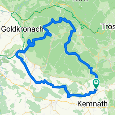
Kulmain-Pullenreuth-Platte946m mit Oberpfalzturm(super Aussicht) die letzten ca.300m zum höchsten Punkt im Steinwald mußte ich mein Rad schieben,steil und sehr steinig,weiter zur Ruine Weißenstein-Fuchsmühl-Güttern auf den Steinwaldradweg nach Erbendorf-Schadenreuth und auf dem Radweg bis Kemnath, über Eisersdorf zurück nach Kulmain.
Herliche Aussichten,gut befahrbare Wege mit einigen passablen Anstiegen.
- -:--
- Duration
- 61.7 km
- Distance
- 737 m
- Ascent
- 737 m
- Descent
- ---
- Avg. speed
- ---
- Avg. speed
Continue with Bikemap
Use, edit, or download this cycling route
You would like to ride Steinwaldtour or customize it for your own trip? Here is what you can do with this Bikemap route:
Free features
- Save this route as favorite or in collections
- Copy & plan your own version of this route
- Sync your route with Garmin or Wahoo
Premium features
Free trial for 3 days, or one-time payment. More about Bikemap Premium.
- Navigate this route on iOS & Android
- Export a GPX / KML file of this route
- Create your custom printout (try it for free)
- Download this route for offline navigation
Discover more Premium features.
Get Bikemap PremiumFrom our community
Other popular routes starting in Kulmain
 OMFG
OMFG- Distance
- 61.3 km
- Ascent
- 552 m
- Descent
- 552 m
- Location
- Kulmain, Bavaria, Germany
 when your out of time!
- Distance
- 13.6 km
- Ascent
- 205 m
- Descent
- 205 m
- Location
- Kulmain, Bavaria, Germany
 1. Tag Kulmain-Trebgast 03.07.17
- Distance
- 51.8 km
- Ascent
- 590 m
- Descent
- 771 m
- Location
- Kulmain, Bavaria, Germany
 Himmelsleiter-Ochsenkopf 16.08.11
- Distance
- 70.9 km
- Ascent
- 950 m
- Descent
- 950 m
- Location
- Kulmain, Bavaria, Germany
 Kulmain-Königskron-Schneeberg-Kulmain
- Distance
- 61.1 km
- Ascent
- 877 m
- Descent
- 877 m
- Location
- Kulmain, Bavaria, Germany
 Ochsenkopfgipfel
- Distance
- 58.1 km
- Ascent
- 819 m
- Descent
- 819 m
- Location
- Kulmain, Bavaria, Germany
 Steinwaldtour
- Distance
- 61.7 km
- Ascent
- 737 m
- Descent
- 737 m
- Location
- Kulmain, Bavaria, Germany
 Mountian bike, w/free ride thru woods
- Distance
- 19 km
- Ascent
- 365 m
- Descent
- 367 m
- Location
- Kulmain, Bavaria, Germany
Open it in the app