

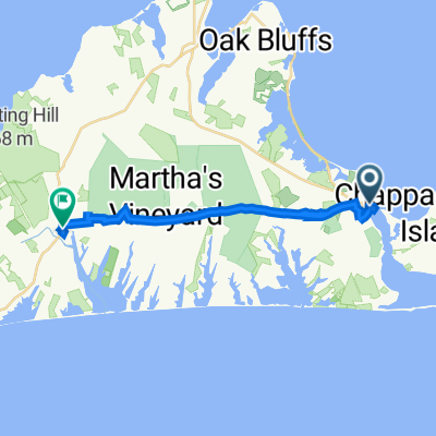
3 Duarte Cir, Edgartown to 10 Duarte Cir, Edgartown
A cycling route starting in Edgartown, Massachusetts, United States of America.
Overview
About this route
- 2 h 7 min
- Duration
- 51.1 km
- Distance
- 0 m
- Ascent
- 8 m
- Descent
- 24.1 km/h
- Avg. speed
- ---
- Avg. speed
Route quality
Waytypes & surfaces along the route
Waytypes
Busy road
32.3 km
(63 %)
Quiet road
13.7 km
(27 %)
Surfaces
Paved
1.9 km
(4 %)
Unpaved
1 km
(2 %)
Asphalt
1.7 km
(3 %)
Ground
1 km
(2 %)
Continue with Bikemap
Use, edit, or download this cycling route
You would like to ride 3 Duarte Cir, Edgartown to 10 Duarte Cir, Edgartown or customize it for your own trip? Here is what you can do with this Bikemap route:
Free features
- Save this route as favorite or in collections
- Copy & plan your own version of this route
- Sync your route with Garmin or Wahoo
Premium features
Free trial for 3 days, or one-time payment. More about Bikemap Premium.
- Navigate this route on iOS & Android
- Export a GPX / KML file of this route
- Create your custom printout (try it for free)
- Download this route for offline navigation
Discover more Premium features.
Get Bikemap PremiumFrom our community
Other popular routes starting in Edgartown
 29 Church St, Edgartown to 119 Manchester Ave, Oak Bluffs
- Distance
- 11.9 km
- Ascent
- 46 m
- Descent
- 27 m
- Location
- Edgartown, Massachusetts, United States of America
 State Forest MV
- Distance
- 33.4 km
- Ascent
- 61 m
- Descent
- 58 m
- Location
- Edgartown, Massachusetts, United States of America
 45 Main St, Edgartown to 1059 State Rd, Chilmark
- Distance
- 19.5 km
- Ascent
- 407 m
- Descent
- 397 m
- Location
- Edgartown, Massachusetts, United States of America
 Katama Loop
- Distance
- 19.1 km
- Ascent
- 8 m
- Descent
- 0 m
- Location
- Edgartown, Massachusetts, United States of America
 edgartown to Alleys
- Distance
- 19.4 km
- Ascent
- 68 m
- Descent
- 63 m
- Location
- Edgartown, Massachusetts, United States of America
 85–199 Fifth St N, Edgartown to 290 W Tisbury Rd, Edgartown
- Distance
- 6.1 km
- Ascent
- 27 m
- Descent
- 32 m
- Location
- Edgartown, Massachusetts, United States of America
 South Beach to Vineyard Haven
- Distance
- 16.9 km
- Ascent
- 74 m
- Descent
- 70 m
- Location
- Edgartown, Massachusetts, United States of America
 Route from 76 Saddle Club Rd, Edgartown
- Distance
- 14.6 km
- Ascent
- 10 m
- Descent
- 13 m
- Location
- Edgartown, Massachusetts, United States of America
Open it in the app